one of the Three Most Scenic Spots in Japan
Sendai-Matsushima area
[ Sendai City, Shiogama City, Tagajo City, Matsushima Town, Shichigahama Town and Rifu Town ]
Area Guides
1Ruins of the Great East Japan Earthquake: Sendai Arahama Elementary School
Locations of disaster memorials
2Ruins of the Great East Japan Earthquake: Residential Foundations in Arahama Area, Sendai City / Monument “Arahama Memorial Bell”
Locations of disaster memorials
3JR Fruits Park Sendai Arahama
Tourists spots
4Kaigan Park Adventure Field
Tourists spots
5Sendai 3.11 Memorial Community Center
Locations of disaster memorials
6AQUAIGNIS SENDAI
Tourists spots
7Shiogama City Tsunami Disaster Prevention Center
Locations of disaster memorials
8Shiogama Seafood Wholesale Market
Tourists spots
9Tagajo City Great East Japan Earthquake Monument
Locations of disaster memorials
10Matsushima Town Ishidasawa Disaster Prevention Center
Locations of disaster memorials
11Matsushima Bay Sightseeing and Storyteller Cruise
Locations of disaster memorials
12Miyagi Prefecture Matsushima Rikyu
Tourists spots
13Fukuurabashi Bridge
Tourists spots
14SHICHINO RESORT
Tourists spots
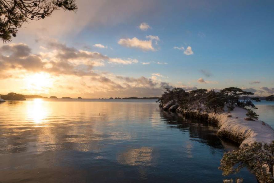
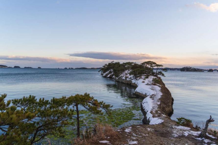
15Umanose, a Natural Pier
Tourists spots
16Tagajo Gourmet Brand, Shiro no Murasaki
Gourmet

17Shiogama City Minato Coast Guard Curry
Gourmet
18Sushi in Shiogama City
Gourmet
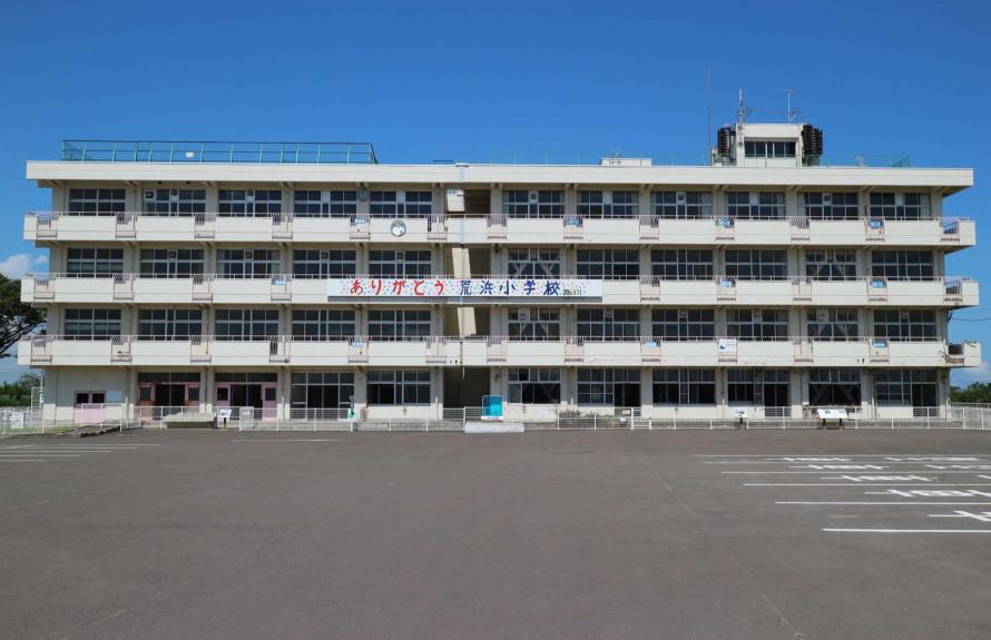
Ruins of the Great East Japan Earthquake: Sendai Arahama Elementary School
Locations of disaster memorials
- 1
-
Ruins of the Great East Japan Earthquake: Sendai Arahama Elementary School
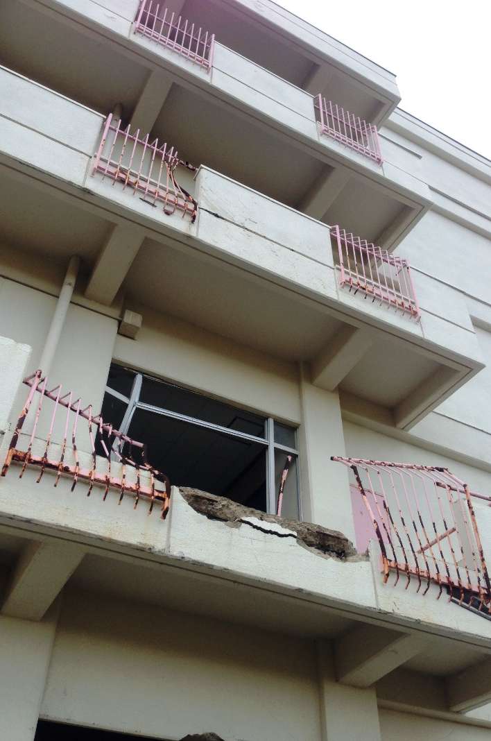
2nd floor east-side veranda wall and handrail damaged by the tsunami
Photographs showing the damage to the school building and the immediate aftermath of the disaster
Ruins of the Great East Japan Earthquake: Sendai Arahama Elementary School is located in the Arahama area on the Pacific coastline approximately 10 km east of central Sendai. The Teizan Canal flows through the area, where once approximately 800 households and 2,200 people settled. The Arahama Elementary School was established in 1873, located about 700 m inland from the shoreline. The school had 91 students in attendance at the time of the disaster. The earthquake damaged the school building, but directly after the earthquake struck, 320 people, including students, school personnel and residents, evacuated to the rooftop and survived being stranded.
Because of this moving story, the school building was left in its damaged state as far as possible to convey to future generations the destructive threat and power of a tsunami, aided by an exhibition inside the school of photographs taken in the aftermath of the tsunami. Visitors will also learn about the history and culture of the Arahama area and discover remembrances of the elementary school. In the exhibition room on the 4th floor, visitors can watch a 17-minute video, “27 Hours Arahama Elementary School March 11, 2011,” which includes interviews and footage of the fire department helicopter from the time of the earthquake to the rescue of all evacuees 27 hours later.
Within walking distance of the school, visitors will find Kaigan Park Adventure Field, a place to have fun and learn more about the natural disaster, as well as the “Arahama Memorial Bell,” a monument built in memory of the victims of the natural disaster.
Languages available: English, Chinese (simplified), Chinese (traditional), Korean, Thai
• There are videos with both Japanese and English subtitles.
• Pamphlets are available in English, Chinese (simplified), Chinese (traditional), Korean, and Thai.
Address: 32-1 Shinborihata, Arahama, Wakabayashi Ward, Sendai City
Phone: 022-355-8517
Hours: 9:30 a.m. – 4:00 p.m. (September to June), 9:30 a.m. – 5:00 p.m. (July to August)
Closed: Mondays and 4th Thursdays (excluding national holidays), year-end/New Year holiday (December 29–January 4)
Admission: Free
Access: Approximately 15 minutes by Sendai City Bus from Arai Station on the Sendai Subway Tozai Line (get off at the last stop, Shinsai Iko Sendai Shiritsu Arahama Shogakko Mae)
Website: https://arahama.sendai311-memorial.jp
Sendai City
Located roughly in the center of Miyagi Prefecture, Sendai City has developed as an important hub of the Tohoku region with a population of over one million. Although it functions as a major city, Sendai City is also known for its rich natural beauty, which includes the Hirose River that runs through the city and the zelkova trees that line the streets, which gave Sendai the nickname “City of Trees.” Sendai City is also known for its academic culture, as it is home to numerous universities and other institutions of higher education in the city and its environs. In the Great East Japan Earthquake, the eastern coastal area of Sendai City was severely damaged by the tsunami, resulting in 923 deaths (including disaster-related fatalities) and 27 people missing. 30,034 houses were completely destroyed and 109,609 houses were partially damaged.*
* Source: Damage from the Great East Japan Earthquake, as of September 30, 2022 (Reconstruction and Crisis Management General Affairs Division, Reconstruction and Crisis Management Department, Miyagi Prefecture)
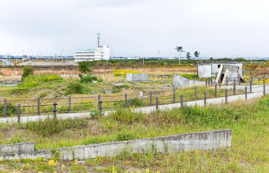
Residential Foundations in Arahama Area, Sendai City
Locations of disaster memorials
- 2
-
Ruins of the Great East Japan Earthquake: Residential Foundations in Arahama Area, Sendai City / Monument “Arahama Memorial Bell”
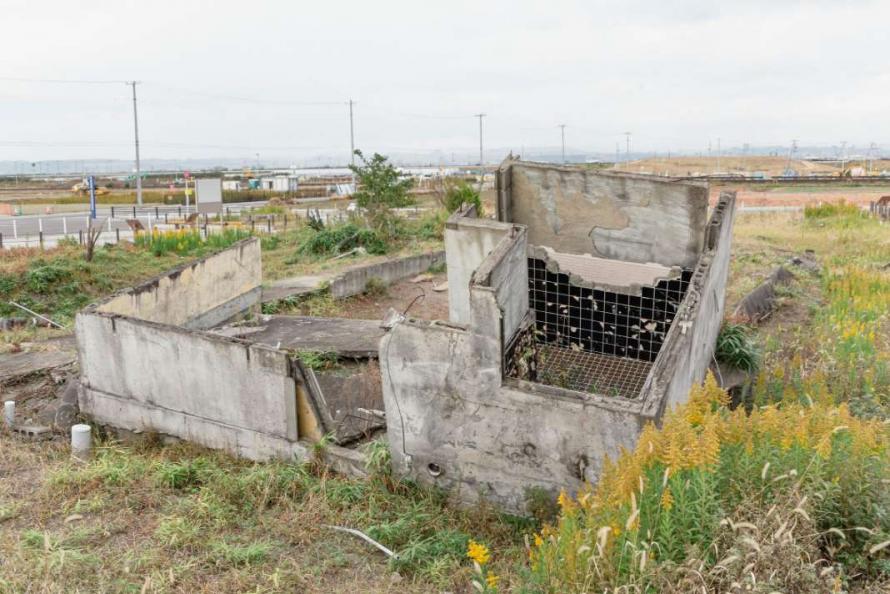
Remains of the foundation of a house destroyed in the tsunami
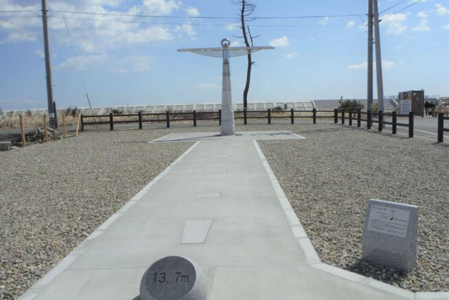
Monument to ensure that Arahama will never be forgotten
The remaining foundations of homes damaged by the tsunami are preserved at this site, located about seven minutes on foot from Ruins of the Great East Japan Earthquake: Sendai Arahama Elementary School. The site aims to convey the terror of the tsunami and preserve the memory of residents’ lives and the community that thrived here before the disaster, as well as raise awareness of disaster readiness. Explanatory signboards explain the threat of a tsunami and provide photographs and testimonies of the community life that was lost in Arahama. By viewing the actual foundations of destroyed houses, visitors can get a visceral sense of the true extent of the tsunami damage.
Also located on the site is the “Arahama Memory Bell,” a monument built in tribute to those who lost their lives in the Great East Japan Earthquake that aims to ensure that Arahama will never be forgotten. The maximum height of the tsunami that hit Arahama that day is said to have reached 13.7 meters (measured from traces of dead pine trees immediately after the disaster), which is represented by the distance from the spherical stone (engraved with “13.7 m”) that leads to the monument. By visiting this site, visitors can get a felt sense of the massiveness of the tsunami.
Address: 25 Aza Nakacho, Wakabayashi Ward, Sendai City, Miyagi Prefecture
Admission: Free
Access: About 15 minutes by Sendai City Bus from Arai Station on the Sendai City Subway Tozai Line, and about a 7-minute walk from the last stop, Shinsai Iko Sendai Shiritsu Arahama Shogakko Mae
Website: https://arahama.sendai311-memorial.jp/residential_foundation/index.html
Sendai City
Located roughly in the center of Miyagi Prefecture, Sendai City has developed as an important hub of the Tohoku region with a population of over one million. Although it functions as a major city, Sendai City is also known for its rich natural beauty, which includes the Hirose River that runs through the city and the zelkova trees that line the streets, which gave Sendai the nickname “City of Trees.” Sendai City is also known for its academic culture, as it is home to numerous universities and other institutions of higher education in the city and its environs. In the Great East Japan Earthquake, the eastern coastal area of Sendai City was severely damaged by the tsunami, resulting in 923 deaths (including disaster-related fatalities) and 27 people missing. 30,034 houses were completely destroyed and 109,609 houses were partially damaged.*
* Source: Damage from the Great East Japan Earthquake, as of September 30, 2022 (Reconstruction and Crisis Management General Affairs Division, Reconstruction and Crisis Management Department, Miyagi Prefecture)
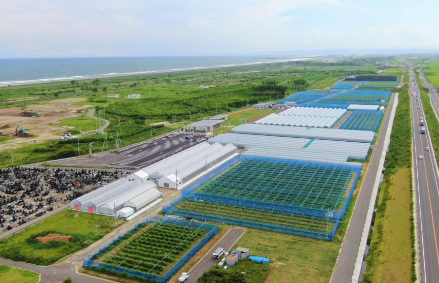
JR Fruit Park Sendai Arahama
Tourists spots
- 3
-
JR Fruits Park Sendai Arahama
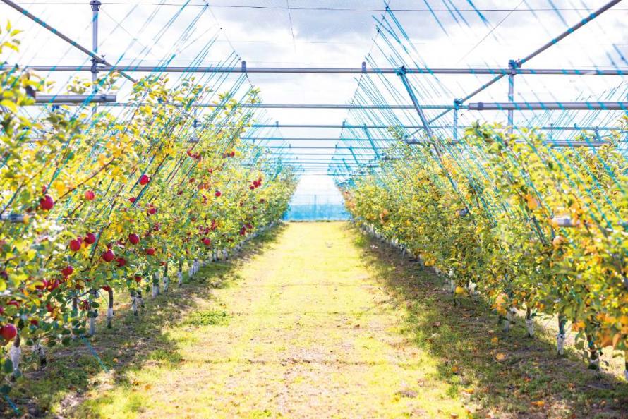
A tourist-friendly orchard where fruit can be picked year round

Enjoy dishes and desserts made with seasonal ingredients from the farm and region at the adjacent restaurant café
Arahama, an area located close to the sea, was once a well-populated, idyllic area with rice and vegetable fields stretching in every direction. This fruits park was established on a former residential district in Sendai. Its mission is to make the Arahama area a place where laughter and smiles can be heard once again. It is located to the south of the Ruins of the Great East Japan Earthquake: Sendai Arahama Elementary School.
The park’s concept is to attract tourists with orchards for fruit-picking all year round. Eight types of fruit and more than 150 varieties are being cultivated, including strawberries, apples, and blueberries. Depending on the season, visitors can even pick more than one type of fruit. Arahama Marché is a farmers’ market that sells locally grown rice and vegetables, and fruit from the orchards. Les Pommes is a café/restaurant produced by a chef from a famous urban hotel where visitors can enjoy dishes, desserts, and drinks that feature seasonal ingredients from the orchard and the region. Fruit picking may be available without reservations on the day of a visit, but same-day reservations are not accepted, so it is better to make a reservation in advance. Reservations can be made by phone (022-290-0766) or through the website.
Address: Arahama Area, Wakabayashi Ward, Sendai City
Phone: 022-390-0770
Hours: 10:00 a.m. – 5:00 p.m.
Closed: Tuesdays (the following day if Tuesday is a holiday), year-end/New Year holiday (December 29–January 3)
Admission: Free (but a fee is required for guided group tours, including school trips)
Fee required for fruit picking (see the facility’s website for details)
Access: About 15 minutes by City Bus from Arai Station on the Subway Tozai Line, and about a 5-minute walk from the bus stop
Website: https://stbl-fruit-farm.jp/arahama/
Sendai City
Located roughly in the center of Miyagi Prefecture, Sendai City has developed as an important hub of the Tohoku region with a population of over one million. Although it functions as a major city, Sendai City is also known for its rich natural beauty, which includes the Hirose River that runs through the city and the zelkova trees that line the streets, which gave Sendai the nickname “City of Trees.” Sendai City is also known for its academic culture, as it is home to numerous universities and other institutions of higher education in the city and its environs. In the Great East Japan Earthquake, the eastern coastal area of Sendai City was severely damaged by the tsunami, resulting in 923 deaths (including disaster-related fatalities) and 27 people missing. 30,034 houses were completely destroyed and 109,609 houses were partially damaged.*
* Source: Damage from the Great East Japan Earthquake, as of September 30, 2022 (Reconstruction and Crisis Management General Affairs Division, Reconstruction and Crisis Management Department, Miyagi Prefecture)
Kaigan Park Adventure Field
Tourists spots
- 4
-
Kaigan Park Adventure Field
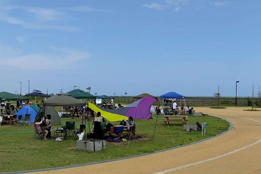
Day-camp site where you can have a barbecue
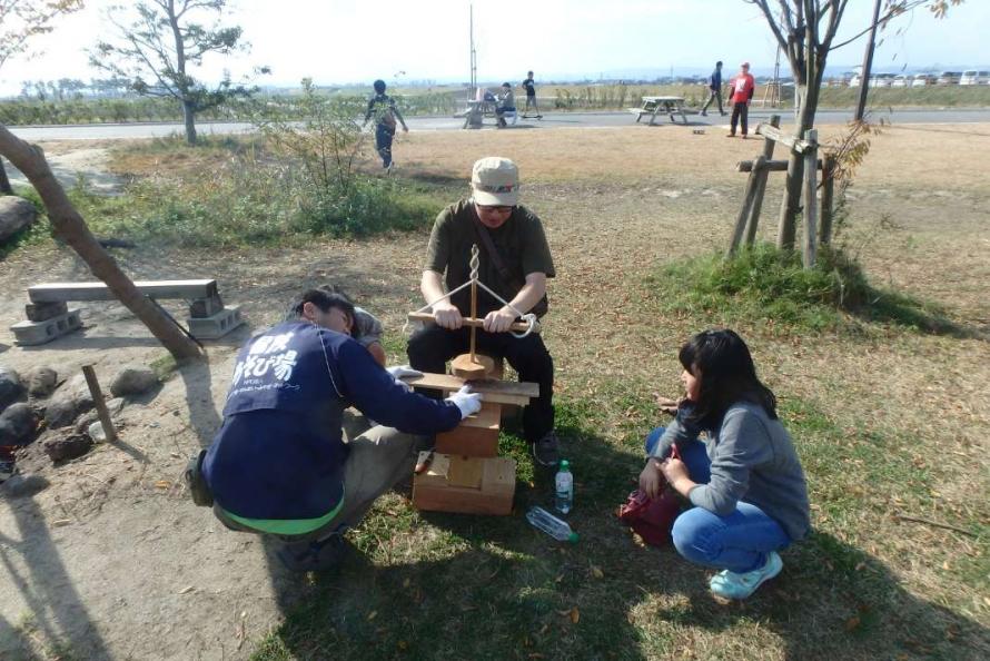
Learn disaster skills (how to start a fire)
Located south of JR Fruit Park Sendai Arahama, this park offers a view of the Pacific Ocean to the east and the Sendai Plain to the west from the hill observatory. The park has a day-camp site where visitors can barbecue, in addition to an adventure-style playground that encourages children to play creatively, an area with large playground equipment that includes a “fluffy” air trampoline (fuwafuwa dome), and a playground for young children with sandbox and swings. The park is designed to be enjoyed by children and adults alike.
There are also spots throughout the park where visitors can learn about the disaster. Trees uprooted by the tsunami, together with information boards, are displayed to provide a sense of the menacing side of nature. Plus, the presence of Evacuation Hill and the signboards that guide people to it will also help turn people’s attention toward preparedness for possible future disasters. Visitors also have the opportunity to learn about Sendai’s tsunami countermeasures, which include evacuation and the concept of multiple defenses. Park staff will be happy to answer any questions. It is possible to participate in disaster prevention drills held regularly on the premises, and group tours are also provided (advance consultation required).
Address: 139-1 Aza Kaihatsu Ido, Wakabayashi Ward, Sendai City
Phone: 022-289-6232
Hours: 9:00 a.m. – 5:00 p.m.
Closed: Tuesdays (the following day if Tuesday is a holiday), year-end/New Year holiday (December 28–January 4)
Admission: Free, but a fee required for the day-camp site (see the facility’s website for details)
Access: About 15 minutes by City Bus from Arai Station on the Sendai Subway Tozai Line, and about a 30-minute walk from the bus stop
Website: https://bouken-asobiba-net.com/bouhiro/
Sendai City
Located roughly in the center of Miyagi Prefecture, Sendai City has developed as an important hub of the Tohoku region with a population of over one million. Although it functions as a major city, Sendai City is also known for its rich natural beauty, which includes the Hirose River that runs through the city and the zelkova trees that line the streets, which gave Sendai the nickname “City of Trees.” Sendai City is also known for its academic culture, as it is home to numerous universities and other institutions of higher education in the city and its environs. In the Great East Japan Earthquake, the eastern coastal area of Sendai City was severely damaged by the tsunami, resulting in 923 deaths (including disaster-related fatalities) and 27 people missing. 30,034 houses were completely destroyed and 109,609 houses were partially damaged.*
* Source: Damage from the Great East Japan Earthquake, as of September 30, 2022 (Reconstruction and Crisis Management General Affairs Division, Reconstruction and Crisis Management Department, Miyagi Prefecture)
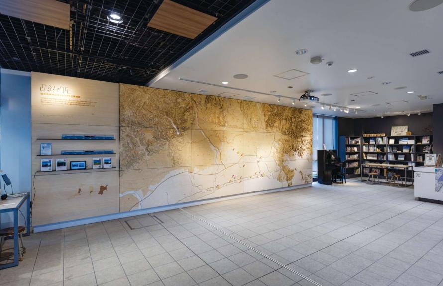
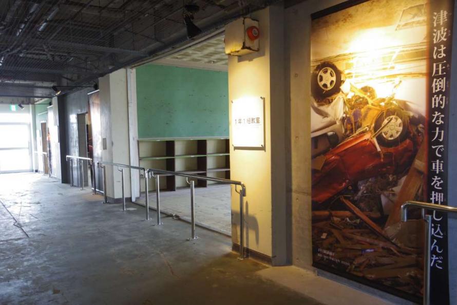
1st Floor: 3D topographic map of the tsunami flood zone
Locations of disaster memorials
- 5
-
Sendai 3.11 Memorial Community Center
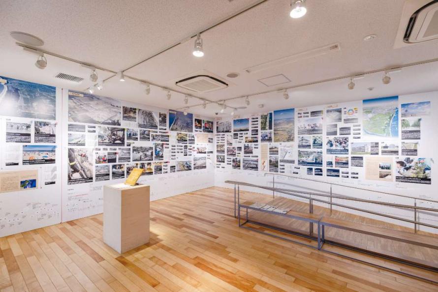
Permanent exhibition in 2nd floor exhibition room
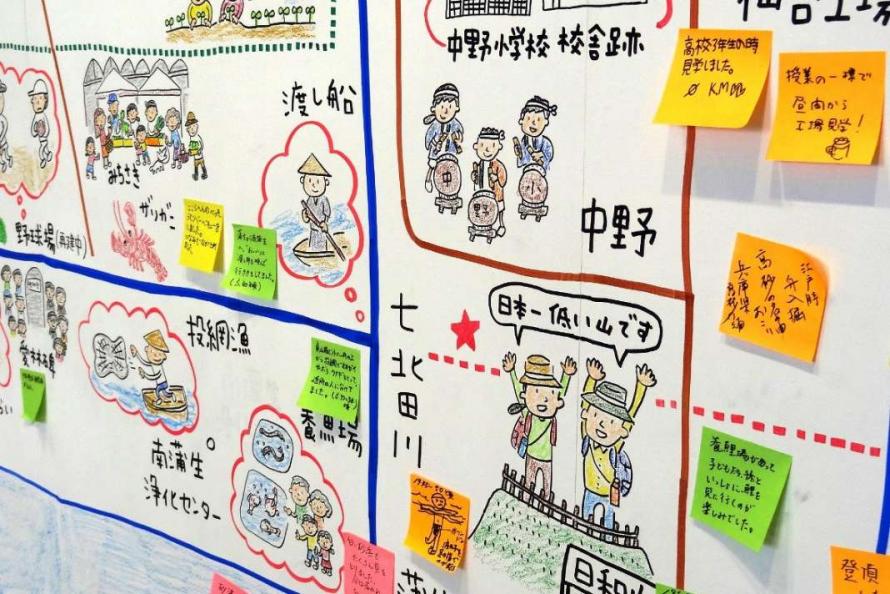
2nd Floor: Illustrated Map of the Sendai Coast (participatory exhibition)
Arai Station is the eastern starting point of the Sendai Subway Tozai Line and the gateway to the eastern coastal area of Sendai, which was severely damaged by the tsunami. The community center, which is right at the station, was established as a place to disseminate to the world the lessons learned and wisdom gained from the Great East Japan Earthquake and tsunami, providing opportunities for communication about the disaster to people from many different backgrounds who pass through the station.
The community space on the first floor features a 3D topographic map, plus slides and related books for learning about Sendai’s eastern coastal area. The exhibition room on the second floor has a permanent exhibition that shows the damage caused by the earthquake and tsunami and the state of restoration and reconstruction in the city, plus special exhibitions that present the natural disaster through various lenses. A range of exhibitions have been held so far, including photographs of life and landscapes in the eastern coastal area of Sendai City before the earthquake, and scientific displays that answer questions about natural phenomena such as earthquakes and tsunamis. There is a rooftop garden on the third floor where visitors can take a break, which is also used as an event space.
A unique exhibit is the Sendai Coast Illustration Map on the second floor. Illustrator Junko Sato, who lives in Sendai, has created an “updating” map of the coastal area that draws out the memories of visitors who are allowed to post sticky notes about their past memories of those places, making it a participatory exhibition.
The “Our 3.11” exhibit on the landing of the staircase connecting the first and second floors invites visitors to write their experiences of that fateful day on the front of a strip of paper, and on the back write their wishes for the future, which they hang on the wall. Currently, there are over 800 strips of paper. Each person who stops by plays an important role in ongoing activities to disseminate information.
Languages available: English, Chinese (simplified), Chinese (traditional), Korean, Thai
• Pamphlets available in English, Chinese (simplified), Chinese (traditional), Korean, and Thai
• Some exhibits are written in both Japanese and English.
Address: 85-4 Kutsugata, Arai, Wakabayashi Ward, Sendai City (inside Arai Station on the Sendai Subway Tozai Line)
Phone: 022-390-9022
Hours: 10:00 a.m. – 5:00 p.m.
Closed: Mondays (the following day if Monday is a holiday), the day after a holiday (excluding Saturdays, Sundays and holidays), year-end/New Year holiday
Admission: Free
Access: At Arai Station on the Sendai Subway Tozai Line
Website: https://sendai311-memorial.jp/
Sendai City
Located roughly in the center of Miyagi Prefecture, Sendai City has developed as an important hub of the Tohoku region with a population of over one million. Although it functions as a major city, Sendai City is also known for its rich natural beauty, which includes the Hirose River that runs through the city and the zelkova trees that line the streets, which gave Sendai the nickname “City of Trees.” Sendai City is also known for its academic culture, as it is home to numerous universities and other institutions of higher education in the city and its environs. In the Great East Japan Earthquake, the eastern coastal area of Sendai City was severely damaged by the tsunami, resulting in 923 deaths (including disaster-related fatalities) and 27 people missing. 30,034 houses were completely destroyed and 109,609 houses were partially damaged.*
* Source: Damage from the Great East Japan Earthquake, as of September 30, 2022 (Reconstruction and Crisis Management General Affairs Division, Reconstruction and Crisis Management Department, Miyagi Prefecture)
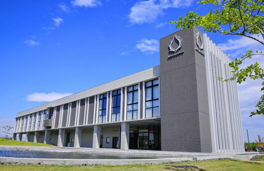
AQUAIGNIS SENDAI
Tourists spots
- 6
-
AQUAIGNIS SENDAI
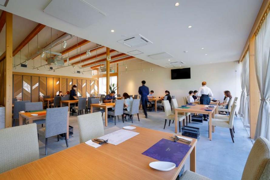
Restaurant
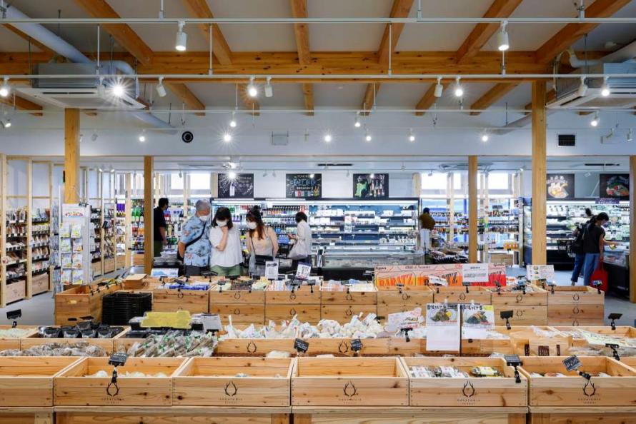
Marché
This is a complex featuring a hot spring spa plus two patisseries, a bakery, Japanese and Italian restaurants, a café, farmers’ market, greenhouse, nursery school, and other facilities. It is located in the Fujitsuka area, south of Kaigan Park Adventure Field. Before the earthquake, the Fujitsuka area, located on the eastern coast of Sendai City, had a vibrant community in a tranquil rural setting, with ferry boats running to and from the Yuriage area, as well as boat transportation via the Teizan Canal across the Natori River. After the tsunami, this area could no longer as a residential district. This facility was constructed here to offer a place for local people and visitors to gather and to enjoy the attractions of food, agricultural produce, and hot springs.
The hot spring building stands on a hill overlooking the coast and houses the hot spring “Fujitsuka no Yu,” which includes a dry sauna and private bath space. The facility also includes a library café, a relaxation space, Japanese restaurant, and shop with a variety of goods related to Sendai and Miyagi. Next door is the café and marché. The market offers fruits, vegetables, and processed foods from local producers in Sendai and Miyagi, as well as from producers in other locations who maintain valuable ties with this region. The patisserie, bakery, and restaurants are supervised by renowned chefs who aim to promote local production for local consumption. Of particular note is that the hot spring facilities incorporate a system that utilizes geothermal and wastewater heat, among other technologies that contribute to a sustainable regional future.
Address: 33-3 Matsunonishi, Fujitsuka, Wakabayashi Ward, Sendai City
Phone: 022-355-2181 (Representative)
Closed: Unscheduled days (varies depending on the shop)
Fujitsuka-no-Yu bath: Fee required (see the facility’s website for details)
Private bath usage: Fee required (see the facility’s website for details)
Access: About 20 minutes by free shuttle bus from Arai Station on the Sendai Subway Tozai Line
Website: https://aquaignis-sendai.jp/
Sendai City
Located roughly in the center of Miyagi Prefecture, Sendai City has developed as an important hub of the Tohoku region with a population of over one million. Although it functions as a major city, Sendai City is also known for its rich natural beauty, which includes the Hirose River that runs through the city and the zelkova trees that line the streets, which gave Sendai the nickname “City of Trees.” Sendai City is also known for its academic culture, as it is home to numerous universities and other institutions of higher education in the city and its environs. In the Great East Japan Earthquake, the eastern coastal area of Sendai City was severely damaged by the tsunami, resulting in 923 deaths (including disaster-related fatalities) and 27 people missing. 30,034 houses were completely destroyed and 109,609 houses were partially damaged.*
* Source: Damage from the Great East Japan Earthquake, as of September 30, 2022 (Reconstruction and Crisis Management General Affairs Division, Reconstruction and Crisis Management Department, Miyagi Prefecture)
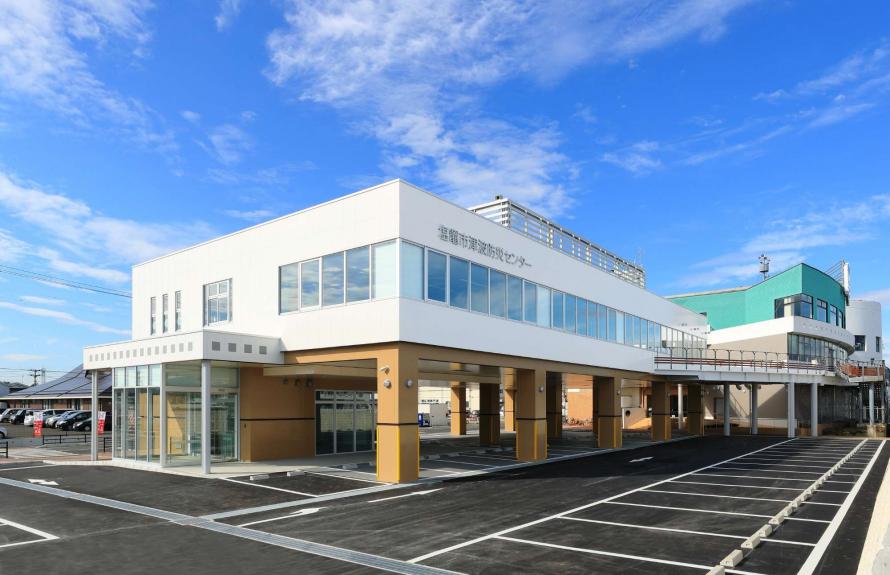
Shiogama City Tsunami Disaster Prevention Center
Locations of disaster memorials
- 7
-
Shiogama City Tsunami Disaster Prevention Center
Record of the seven days after the disaster (hanging scrolls)
Learning from “Seeds of Knowledge” visual simulation (3-screen display)
The Shiogama City Tsunami Disaster Prevention Center is located along the wharf at the Shiogama port within walking distance of JR Hon-Shiogama Station. It is a learning center whose main exhibit focuses on the week following the 2011 tsunami—what actually occurred and what damage was suffered—to communicate the lessons learned and raise awareness of disaster preparedness.
Visitors can enjoy an interactive learning experience using a jog dial to control a three-screen display system that simulates the seven days following the earthquake, based on actual images and records. The three-screen display system is called “Seeds of Knowledge.” Also on display is the actual compass from a Miyagi Coast Guard patrol vessel, the Matsushima, which was about 5 kilometers off the coast of Soma City, Fukushima Prefecture, when it encountered the massive tsunami. The boat managed to ride over the towering 10-meter-high waves by facing them head-on. Visitors can virtually experience that encounter at sea through actual footage.
Marine Gate Shiogama, adjacent to the center, is a shopping and dining complex that also serves as the boarding point and information center for the Matsushima cruise boat that tours the islands of Matsushima Bay and the public ferry that takes people to the Urato Islands. The first floor has souvenir shops and the second floor has restaurants where visitors can enjoy fresh Shiogama cuisine. The third-floor observation deck offers a view of the ships coming in and out of Shiogama Port.
Address: 1-4-1 Minatomachi, Shiogama City
Phone: 022-794-7232
Hours: 9:00 a.m. – 5:00 p.m.
Closed: Mondays (the following day if Monday is a holiday), every second Tuesday (the following day if it is a holiday), year-end/New Year holiday (December 29–January 3), and other temporary closures
Admission: Free
Access: About a 10-minute walk from JR Hon-Shiogama Station on the Senseki Line
About 12 minutes by car from the Sanriku Expressway Rifu Central IC
Website: https://www.city.shiogama.miyagi.jp/soshiki/9/2479.html
Shiogama City
The city of Shiogama, which looks out toward Matsushima Bay, includes the Urato Islands (a nationally designated Special Place of Scenic Beauty). The primary industry in Shiogama is fishing, with an annual catch valued at around 9 billion yen. Shiogama is known especially for its fresh tuna, boasting one of the highest catch volumes in Japan. The city is also a leading producer of fish paste products such as kamaboko and is known for its nori seaweed and oysters. In terms of tourism, around 950,000 people annually visit Shiogama Shrine, ranked as Oshu Ichinomiya (one of the major shrines of the Tohoku region), and the Urato Islands also attract people for swimming, hiking, and other outdoor activities.
Besides earthquake damage in the Great East Japan Earthquake, the coastal areas and the Urato area were severely affected by the tsunami, with most residential areas in the Urato area flooded out. The local economy was acutely hurt, with extensive damage to fisheries and fish processing plants, port-related industries, and shallow-water aquaculture.
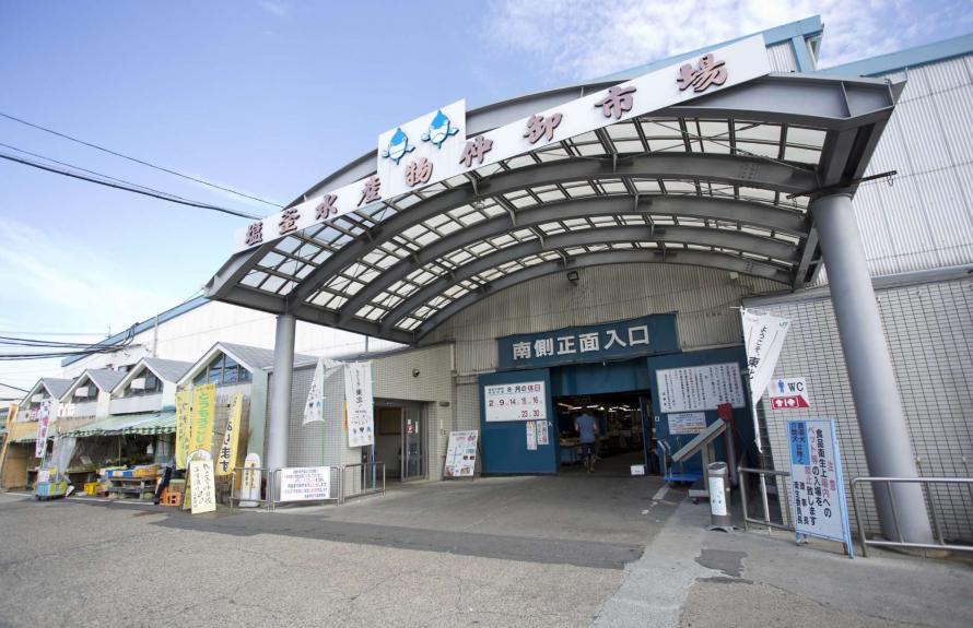
Shiogama Seafood Wholesale Market
Tourists spots
- 8
-
Shiogama Seafood Wholesale Market
Specialty stalls sell fresh fish and processed marine products
on the spacious premises
“My Kaisendon” (self-prepared seafood rice bowl) is very popular
among tourists
The Shiogama fishing port, known for its fresh tuna caught in coastal waters, attracts fishing boats from all over Japan to offload catches from the Sanriku fishing grounds, one of the three most productive regions in the world. The Shiogama Seafood Wholesale Market is a rare wholesale market in Japan open to the general public, allowing people to buy fresh fish and processed products at wholesale prices. It is open from early morning (3 a.m.) (6 a.m. on Sundays and holidays) to 1 p.m. (2 p.m. on Sundays and holidays).
The spacious market area, which houses about 90 stalls specializing in fresh fish and processed seafood products, attracts large numbers of visitors every day. The market is particularly known for the high-end bigeye tuna landed only from early autumn to winter and sold under the brand Sanriku Shiogama Higashimono.
The market features a dining area offering fresh seafood meals, and there are also gyoza (dumpling) and ramen restaurants, cafés, and shops that sell sweets. Very popular among tourists is the “My Kaisendon” experience, where you choose your preferred sashimi (available in packs), go to the “My Kaisendon Corner” located at the back of the market, order a rice set, and arrange a seafood rice bowl to your liking. If you go with a few people, you can all share and enjoy a wider variety of seafood. A barbecue area is available outdoors for grilling shrimp and shellfish on your own.
Address: 1-20-74 Shinhama-cho, Shiogama City
Phone: 022-362-5518
Hours: Weekdays 3:00 a.m. – 1:00 p.m., Saturdays 3:00 a.m. – 2:00 p.m., Sundays and holidays 6:00 a.m. – 2:00 p.m.
Closed: Wednesdays (with occasional days open), New Year and Obon holidays
Admission: Free
Access: About 10 minutes by Shionavi Bus from JR Hon-Shiogama Station or 10 minutes by car from Marine Gate Shiogama
Website: https://www.nakaoroshi.or.jp/
Shiogama City
The city of Shiogama, which looks out toward Matsushima Bay, includes the Urato Islands (a nationally designated Special Place of Scenic Beauty). The primary industry in Shiogama is fishing, with an annual catch valued at around 9 billion yen. Shiogama is known especially for its fresh tuna, boasting one of the highest catch volumes in Japan. The city is also a leading producer of fish paste products such as kamaboko and is known for its nori seaweed and oysters. In terms of tourism, around 950,000 people annually visit Shiogama Shrine, ranked as Oshu Ichinomiya (one of the major shrines of the Tohoku region), and the Urato Islands also attract people for swimming, hiking, and other outdoor activities.
Besides earthquake damage in the Great East Japan Earthquake, the coastal areas and the Urato area were severely affected by the tsunami, with most residential areas in the Urato area flooded out. The local economy was acutely hurt, with extensive damage to fisheries and fish processing plants, port-related industries, and shallow-water aquaculture.
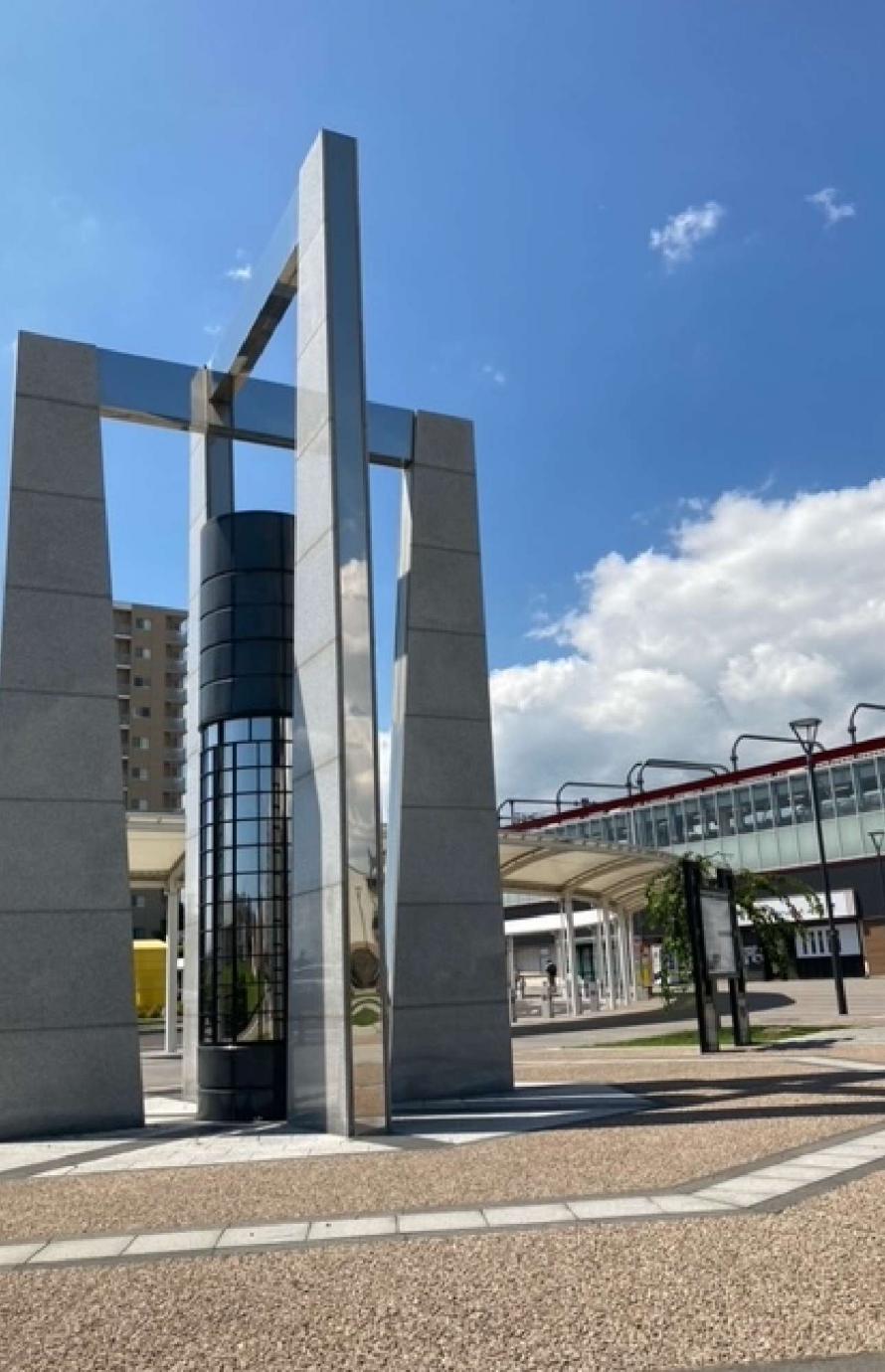
Tagajo City Great East Japan Earthquake Monument
Locations of disaster memorials
- 9
-
Tagajo City Great East Japan Earthquake Monument
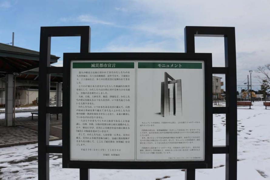
Adjacent display board
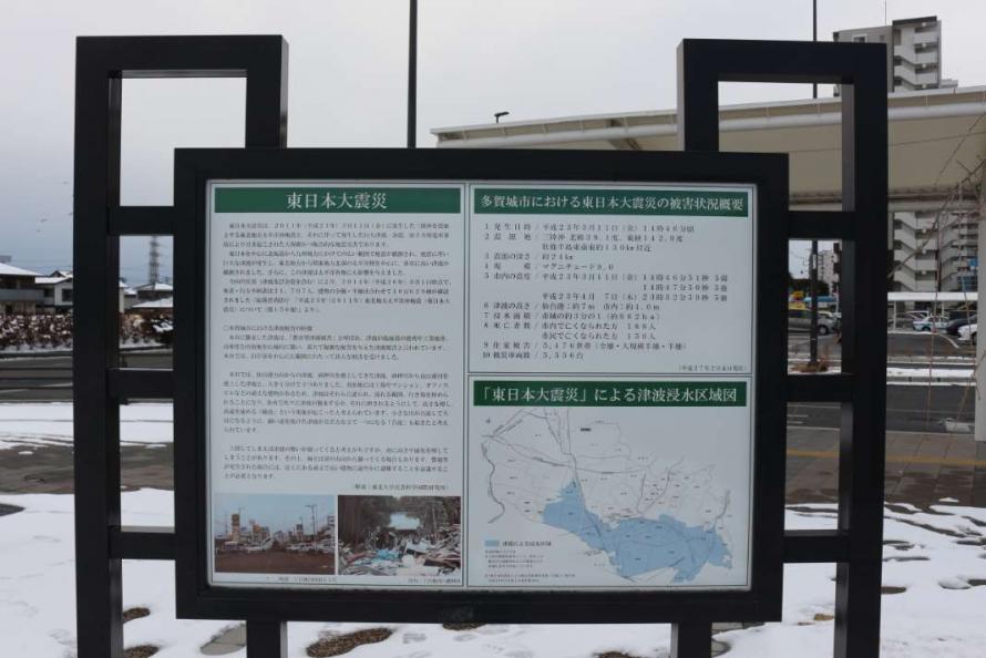
Adjacent display board
Composed of two stainless steel and granite arches over a powerful central column, the monument was installed to mourn the victims of the Great East Japan Earthquake, to pass on the knowledge gained and lessons learned from the experience, and to enshrine an oath to mitigate the damage of future disasters. The two crossing arches express the determination to ensure that the memory of the disaster will be passed down for generations to come without interruption. The cylindrical column, which stands 4.6 meters high—the peak height reached by the tsunami that hit Tagajo City—serves as a remembrance of the Great East Japan Earthquake in its scale and design.
The adjacent display boards present in Japanese text an overview of the Great East Japan Earthquake, the damage incurred in Tagajo City, a map of the areas flooded by the tsunami, an explanation of the monument’s design, and a “disaster mitigation city” declaration. The monument will serve as a reminder of the earthquake and tsunami not only for citizens but also for visitors from other areas and generations that did not experience the natural disaster.
Address: 2-7, Tagajo City
Phone: 022-368-1141 (main number) (Administrative Office, General Affairs Department, General Affairs Division, Tagajo City)
Admission: free
Access: About a 1-minute walk from JR Tagajo Station
Website: https://www.city.tagajo.miyagi.jp/hisho/kurashi/monument/monument.html
Tagajo City
Tagajo City is a municipality adjacent to the neighboring city of Sendai. The area has a variety of features, such as stretches of rice paddies reminiscent of ancient Japan, bustling shops along the national highway, and the Teizan Canal—the longest canal in Japan. The canal itself extends from the mouth of the Abukuma River to the former Kitakami River in Ishinomaki City, passing along the coast of Sendai, connecting Shiogama Bay and the coast of Higashi-Matsushima City. Many historical sites can be found in Tagajo City, dating from the prehistoric Jomon Period to modern times, including the Taga Castle Monument, an engraved stone that marks the founding of Taga Castle. Currently, the restoration work is underway on the south gate of Taga Castle in preparation for its opening to the public in 2024, the 1300th anniversary of the castle’s founding (as of March 2023).
The Great East Japan Earthquake, which registered an intensity of 5 upper on the Japanese seismic scale, caused a tsunami that reached approximately 7 meters in height at Sendai Port. A tsunami 2 to 4 meters in height reached Tagajo City, flooding 662 hectares of land, one-third of the total land area of the municipality. Two planned roadways were opened in 2021 as evacuation routes to inland areas in the event of a tsunami—the Shimizusawa–Tagajo road and Kasagami Hachiman road.
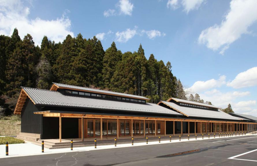
Matsushima Town Ishidasawa Disaster Prevention Center
Locations of disaster memorials
- 10
-
Matsushima Town Ishidasawa Disaster Prevention Center
Exhibition area (panels)
Exhibition area (video)
This facility is located on a hill overlooking the town and Matsushima Bay, near Saigyo Modoshi no Matsu Park and the Byakui Kannon Observation Deck, which offers a great view of the bay. It is also close to the city center, allowing visitors to reach the facility on foot. It can be used as a rest area free of charge and also serves as a hub for disaster prevention training programs and educational activities related to disaster resilience.
The building, made with traditional gray roofing tiles and charred cedar planks, was designed to blend in with the natural scenery out of respect for Matsushima as a special place of scenic beauty. It features a 70-meter-long outdoor veranda space, while the indoor exhibition area presents panels that show the damage caused by the Great East Japan Earthquake and the area’s recovery and reconstruction efforts since that time. The facility can shelter up to 450 evacuees and is equipped with an emergency municipal radio system, earthquake-resistant water storage tank, supply stockpile warehouse, and private power generator.
Address: 12-2 Ishidasawa, Matsushima Town, Miyagi District
Phone: 022-354-5782
Hours: 9:00 a.m. – 5:00 p.m. (9:00 a.m. – 4:00 p.m. from November to February)
Closed: Wednesdays, year-end/New Year holiday (December 29–January 3)
Admission: Free for sightseeing and resting; fee required for training and conference rooms (reservations required; see the facility’s website for details)
Access: About a 20-minute walk from JR Matsushima Kaigan Station on the Senseki Line
About 5 minutes by car from JR Matsushima Kaigan Station on the Senseki Line
Website: https://www.town.miyagi-matsushima.lg.jp/index.cfm/6,24662,57,184,html
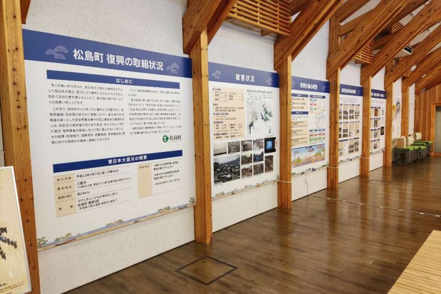
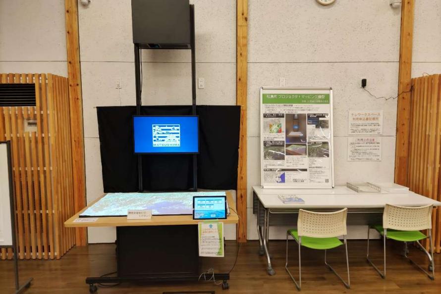
Matsushima Town
Matsushima, which includes Matsushima Bay and its 260-odd islands, is one of Japan’s three most celebrated scenic sights, alongside the pine-covered sandbar of Amanohashidate in Kyoto Prefecture and the “floating” shrine gate of Itsukushima in Hiroshima Prefecture. Matsushima was introduced to the public in a 1643 book written by a neo-Confucian Japanese philosopher, Hayashi Shunsai, as one of the “Three Most Scenic Views of Japan” and has been a popular tourist destination ever since. Matsushima is a nationally designated “place of scenic beauty” and prefectural natural park, and tourist facilities are being developed in the area to be a model for international tourism. Besides tourism, Matsushima Town has a balanced development in agriculture, fishing, and commercial sectors. Also, many valuable historical and cultural heritage sites are found throughout the town, including Zuiganji Temple.
In the Great East Japan Earthquake, the 260-odd islands that make up Matsushima dampened the tsunami’s force, preventing catastrophic damage. However, the town did get inundated, houses collapsed, and lifelines were disrupted. Despite these difficulties, the town received extensive support from both domestic and international sources, and the local community united for a rapid recovery, with tourism and accommodation facilities resuming operations just one month after the disaster, by mid-April.
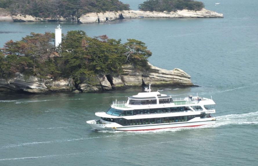
Matsushima Bay Sightseeing and Storyteller Cruise
Locations of disaster memorials
- 11
-
Matsushima Bay Sightseeing and Storyteller Cruise
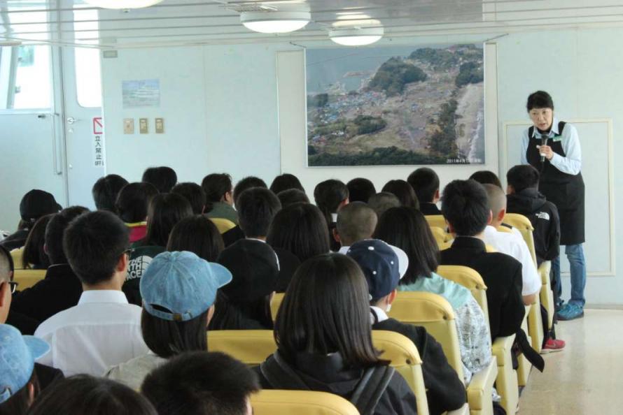
Storytelling onboard
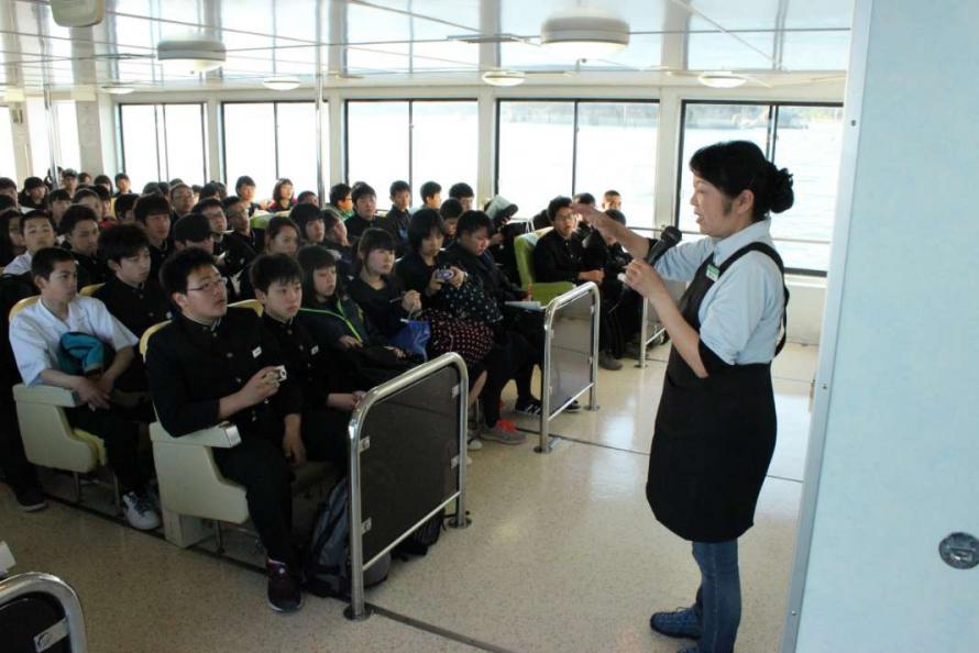
Storytelling onboard
For sightseeing around Matsushima Bay, one of Three Most Scenic Views of Japan, visitors can either take a round-trip cruise from Matsushima or a one-way cruise between Matsushima and Shiogama, starting at either point. Both courses allow you to see the famous scenic islands in Matsushima Bay.
The Matsushima Bay Storyteller Cruise, led by a storyteller guide, gives visitors a chance to hear stories about the Great East Japan Earthquake based on personal experience. The storytelling imparts the importance of being grateful for life and family and the significance of maintaining a sense of awe towards nature.
The cruise is available for school trips, corporate training, and other groups with advance reservations.
Address: Marubun Matsushima Kisen:
98-1 Aza Chonai Matsushima, Matsushima Town, Miyagi District (Matsushima boarding)
1-4-1 Minatomachi, Shiogama City, Miyagi District (Shiogama boarding)
Phone: 022-354-3453 (Marubun Matsushima Kisen)
Closed: Cruises may be changed or suspended due to weather or wave conditions.
Fees: Fee required (see the facility’s website for details)
Access: About a 7-minute walk from JR Matsushima Kaigan Station on the Senseki Line
About a 10-minute walk from JR Hon-Shiogama Station on the Senseki Line
Website: https://www.marubun-kisen.com
Matsushima Town
Matsushima, which includes Matsushima Bay and its 260-odd islands, is one of Japan’s three most celebrated scenic sights, alongside the pine-covered sandbar of Amanohashidate in Kyoto Prefecture and the “floating” shrine gate of Itsukushima in Hiroshima Prefecture. Matsushima was introduced to the public in a 1643 book written by a neo-Confucian Japanese philosopher, Hayashi Shunsai, as one of the “Three Most Scenic Views of Japan” and has been a popular tourist destination ever since. Matsushima is a nationally designated “place of scenic beauty” and prefectural natural park, and tourist facilities are being developed in the area to be a model for international tourism. Besides tourism, Matsushima Town has a balanced development in agriculture, fishing, and commercial sectors. Also, many valuable historical and cultural heritage sites are found throughout the town, including Zuiganji Temple.
In the Great East Japan Earthquake, the 260-odd islands that make up Matsushima dampened the tsunami’s force, preventing catastrophic damage. However, the town did get inundated, houses collapsed, and lifelines were disrupted. Despite these difficulties, the town received extensive support from both domestic and international sources, and the local community united for a rapid recovery, with tourism and accommodation facilities resuming operations just one month after the disaster, by mid-April.
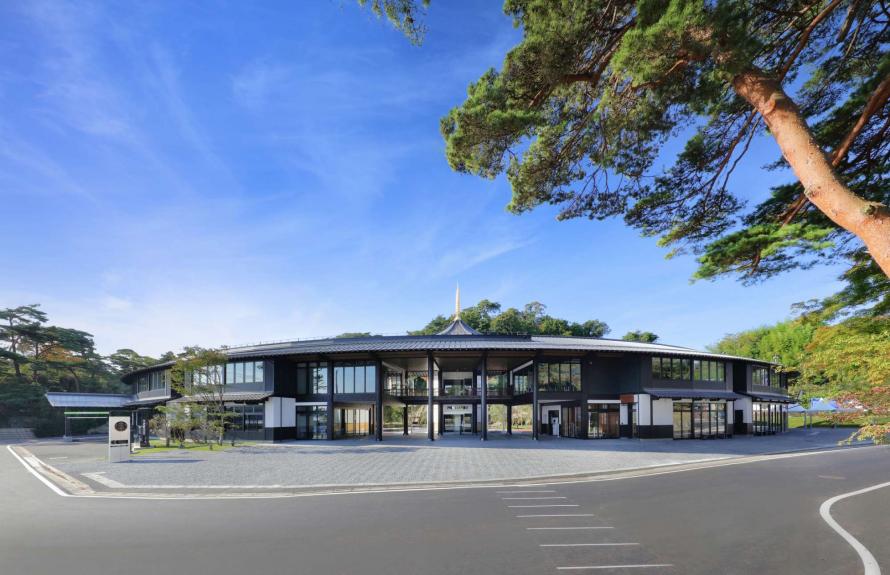
Miyagi Prefecture Matsushima Rikyu
Tourists spots
- 12
-
Miyagi Prefecture Matsushima Rikyu
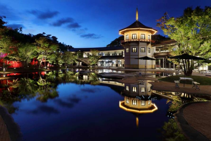
Rikyu Garden, modeled after Matsushima Bay
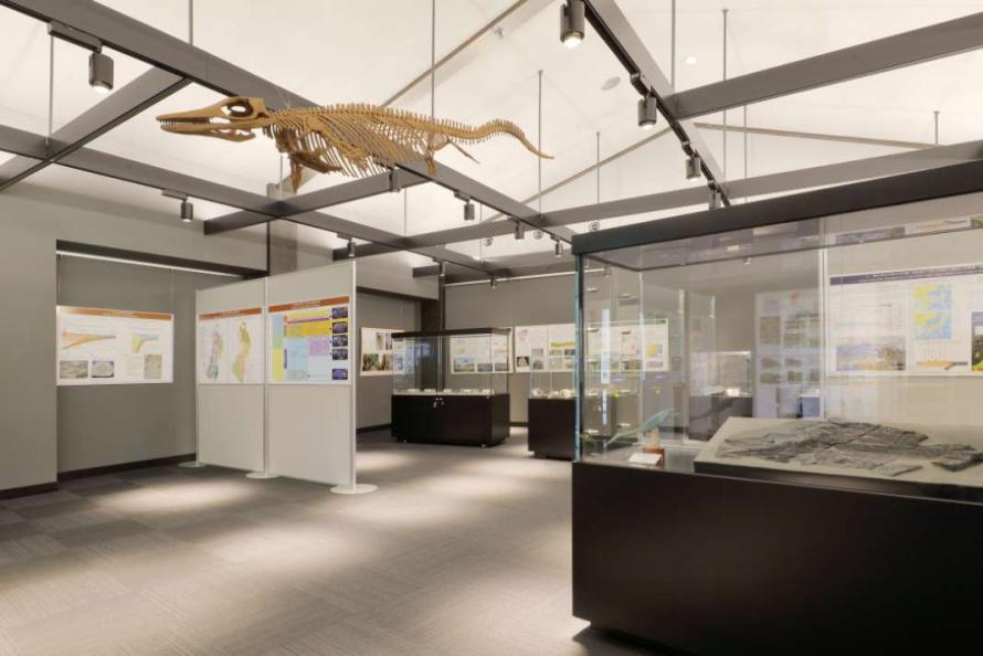
Exhibition of a full-scale model of the oldest ichthyosaur, Utatusaurus
Just a 1-minute walk from JR Matsushima Kaigan Station, this commercial facility opened in 2020 on the site of the former Matsushima Aquarium. Standing in front is a three-story decagonal pagoda-like tower that pays homage to Letzel Tower of the former Matsushima Park Hotel, built in 1913 by the Czech architect. The complex is built around the Rikyu Garden, modeled after Matsushima Bay, and offers many kinds of facilities, including a tourist information center, restaurants, stores, craft-making areas, and a museum. On the rooftop, you can enjoy a barbecue while gazing out over the scenery of Matsushima Bay.
Photographs of Matsushima from the late 19th century on are displayed along the staircase inside the three-story tower. The museum is supervised by Dr. Reishi Takashima, professor at the Tohoku University Center for Academic Resources and Archives and Director of the Tohoku University Museum. It presents the history of Matsushima Bay starting in the prehistoric Jomon period and boasts a life-size model of the Utatsusaurus, which lived about 250 million years ago, the first fossil of which was discovered in Utatsu (now Tatezaki, Minamisanriku Town).
In the dining and shopping area, there is a seafood grill, an all-you-can-eat seafood restaurant, shops selling oyster rice crackers, sweets, bags, and more. A 6-minute walk away is Matsushima Rikyu Umi-no-Eki, another spot for enjoying a variety of seafood dishes.
Within the complex is the multi-purpose Rikyu Hall where hands-on workshops are held based on the concept of “try your hand and learn.” There are more than 30 types of workshops available such as painting kokeshi dolls, which is popular with tourists, making oyster shell dioramas, aroma candles, accessories, glass art, and kaleidoscopes. Outdoor events are also available, including island cruises and kayaking in the bay.
Address: 18 Namiuchihama, Matsushima, Matsushima Town, Miyagi District
Phone: 022-355-0330
Hours: Vary depending on the facility and shop
Closed: Open all year round (some shops are closed on certain days)
Admission: Free entry to the dining and shopping area
Fee required for areas such as the Rikyu Garden and Rikyu Museum, as well as for various experiences (see the facility’s website for details)
Access: About a 1-minute walk from JR Matsushima Kaigan Station on the Senseki Line
About 10 minutes by car from the Sanriku Expressway Matsushima Kaigan IC
Website: https://rikyu-m.com/
Matsushima Town
Matsushima, which includes Matsushima Bay and its 260-odd islands, is one of Japan’s three most celebrated scenic sights, alongside the pine-covered sandbar of Amanohashidate in Kyoto Prefecture and the “floating” shrine gate of Itsukushima in Hiroshima Prefecture. Matsushima was introduced to the public in a 1643 book written by a neo-Confucian Japanese philosopher, Hayashi Shunsai, as one of the “Three Most Scenic Views of Japan” and has been a popular tourist destination ever since. Matsushima is a nationally designated “place of scenic beauty” and prefectural natural park, and tourist facilities are being developed in the area to be a model for international tourism. Besides tourism, Matsushima Town has a balanced development in agriculture, fishing, and commercial sectors. Also, many valuable historical and cultural heritage sites are found throughout the town, including Zuiganji Temple.
In the Great East Japan Earthquake, the 260-odd islands that make up Matsushima dampened the tsunami’s force, preventing catastrophic damage. However, the town did get inundated, houses collapsed, and lifelines were disrupted. Despite these difficulties, the town received extensive support from both domestic and international sources, and the local community united for a rapid recovery, with tourism and accommodation facilities resuming operations just one month after the disaster, by mid-April.
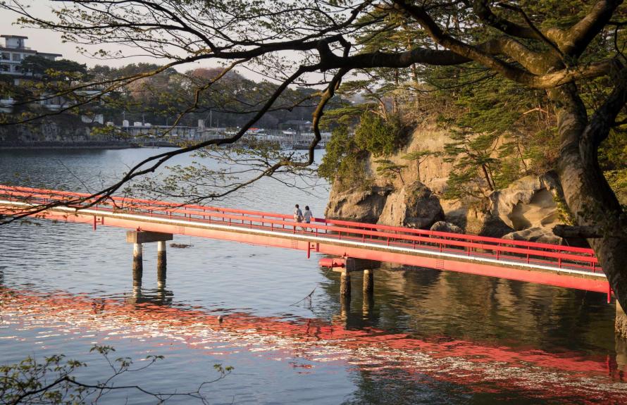
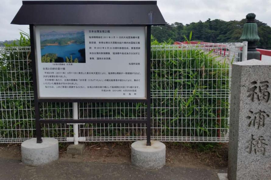
Fukuurabashi Bridge
Tourists spots
- 13
-
Fukuurabashi Bridge
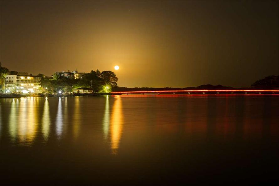
Bridge illumination
Signboard next to the bridge
Fukuurabashi Bridge, known informally as the “Deaibashi (Meeting Bridge),” allows visitors to walk across to Fukuurajima Island in Matsushima Bay. The 252-meter-long bridge had some of its footings damaged by the earthquake, but the bridge was repaired with donations from the sightseeing boat operators of Sun Moon Lake in Taiwan. The bridge is illuminated at dusk all year round, creating a beautiful evening appearance. (The lights are turned off for three days before, during, and after each full moon.)
Across the bridge is Fukuurajima Island, a prefectural park. The six-hectare island is home to over 300 species of plants, and visitors can learn about the flowers and trees through explanatory boards and enjoy the changing appearance of the island with each season. There is also a temple structure dedicated to Benzaiten (Saraswati), plus flower beds, a multi-purpose plaza, and an observation deck from which visitors can enjoy a magnificent view of Matsushima Bay.
Address: 39-1 Senzui, Matsushima, Matsushima Town, Miyagi District
Phone: 022-354-3457 (Café Bayland)
Bridge hours: March to October: 8:30 a.m. – 5:00 p.m., November to February: 8:30 a.m. – 4:30 p.m.
Closed: Open all year round
Admission: Fee required (see each facility’s website for details)
Access: About a 15-minute walk from JR Matsushima Kaigan Station on the Senseki Line
About 10 minutes by car from the Sanriku Expressway Matsushima Kaigan IC
Website: http://www.town.miyagi-matsushima.lg.jp/index.cfm/8,8393,36,html
Matsushima Town
Matsushima, which includes Matsushima Bay and its 260-odd islands, is one of Japan’s three most celebrated scenic sights, alongside the pine-covered sandbar of Amanohashidate in Kyoto Prefecture and the “floating” shrine gate of Itsukushima in Hiroshima Prefecture. Matsushima was introduced to the public in a 1643 book written by a neo-Confucian Japanese philosopher, Hayashi Shunsai, as one of the “Three Most Scenic Views of Japan” and has been a popular tourist destination ever since. Matsushima is a nationally designated “place of scenic beauty” and prefectural natural park, and tourist facilities are being developed in the area to be a model for international tourism. Besides tourism, Matsushima Town has a balanced development in agriculture, fishing, and commercial sectors. Also, many valuable historical and cultural heritage sites are found throughout the town, including Zuiganji Temple.
In the Great East Japan Earthquake, the 260-odd islands that make up Matsushima dampened the tsunami’s force, preventing catastrophic damage. However, the town did get inundated, houses collapsed, and lifelines were disrupted. Despite these difficulties, the town received extensive support from both domestic and international sources, and the local community united for a rapid recovery, with tourism and accommodation facilities resuming operations just one month after the disaster, by mid-April.
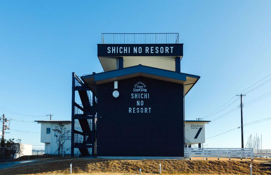
SHICHINO RESORT
Tourists spots
- 14
-
SHICHINO RESORT
Café
Hotel
SHICHINO RESORT consists of a hotel and café restaurant that opened in December 2017 on the seaside in Shichigahama. Many people visit from near and far to spend time relaxing here and enjoying the view of the sea. The café is popular for pizza and pasta made with local ingredients, and pancakes that are light and fluffy. SHICHINO HOTEL has 4 guest rooms, including condominium-style rooms with a kitchen. The hotel attracts families, couples, and groups of friends for a variety of occasions and is a place where you can feel the refreshing sea breeze and have an extraordinary experience. The adjacent Umi-no-Eki Shichinoya is another popular spot where you can eat locally caught seafood. In addition to offering set meals made with fresh seafood, seafood rice bowls, and hamayaki (grilled fresh catch), the shop also has a wide variety of processed marine products that make great souvenirs.
SHICHINO RESORT
Address : 75-65 Aza Tateshita, Hanabuchihama, Shichigahama-machi, Miyagi District
Phone: 022-349-7001
Closed: Unscheduled days
Access: About 15 minutes by car from JR Tagajo Station
Website: https://shichinoresort.com/
Shichigahama Town
Shichigahama is a small town located on the Pacific coast adjacent to the cities of Sendai, Tagajo, and Shiogama, surrounded by the sea on three sides. It is the smallest town in the wider regions of Tohoku and Hokkaido. The name Shichigahama (“seven beaches”) comes from the fact that the town has seven official beaches: Minatohama, Matsugahama, Shobutahama, Hanabuchihama, Yoshidahama, Yogasakihama, and Toguhama. Each beach has its own enchanting shoreline; these are favorite destinations for locals and others who enjoy swimming, marine sports, and fishing.
In the Great East Japan Earthquake, most of the areas facing the sea and canals were hit by the tsunami. Matsugahama, Shobutahama, and Hanabuchihama, where the tsunami rose to over 10 meters, were especially hard hit. There were 79 deaths (including disaster-related fatalities) and extensive damage, with over 674 houses completely destroyed and 650 partially destroyed.* In March 2020, the memorial monument “Beyond the Rainbow” (Niji no Mukou) was built at Chōbō-saki , a point overlooking Shobutahama Beach as a symbol of recovery. The statue of a mother and daughter looking out at the Pacific Ocean conveys the memory of the disaster to future generations.
* Source: Damage from the Great East Japan Earthquake, as of September 30, 2022 (Reconstruction and Crisis Management General Affairs Division, Reconstruction and Crisis Management Department, Miyagi Prefecture)
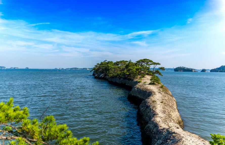
Umanose, a natural pier under blue skies in summer
Tourists spots
- 15
-
Umanose, a Natural Pier
Umanose at sunset
Umanose after a snowfall
The natural formation known as Umanose (“Horse’s Back”) is located in the Hamada area of Rifu Town, about a 5-minute drive south on Route 45 from central Matsushima, which is known for Zuiganji Temple and its Godaido Hall. The shape of the land formation, said to be a “natural pier,” juts out 250 meters into the sea from the land due to erosion by waves measured on a geological time scale. It is an example of great natural beauty formed without human intervention. If you trek through the thick pine trees and reach the far end, you will be treated to a pleasant sea breeze and a scenic view of Matsushima Bay dotted with small islands. Visible on the opposite bank is a smaller peninsula called Ko-uma (“The Foal’s Back”). These are hidden sights of Matsushima that any visitor can enjoy, but beware that the foot trail along Umanose is narrow and not maintained. It takes about 10 minutes to walk from the start to the tip of the peninsula, but there are no handrails or paving, so please be careful and wear good walking shoes.
Address: Hitsugasawa, Akanuma, Rifu Town, Miyagi District
Phone: 022-356-3678 (Rifu Town Tourism Association, Weekdays 10:00 a.m. – 4:00 p.m.)
Admission: Free
Access: About a 20-minute walk from JR Rikuzen-Hamada Station
Website: https://www.town.rifu.miyagi.jp/gyosei/soshikikarasagasu/hisyoseisaku/hisyo/1/4290.html
Rifu Town
Rifu Town is located in the central part of Miyagi Prefecture and has a population of about 36,000. The town has abundant local resources, such as the sea at Omote-Matsushima and specialty Rifu pears. It is an easy place to live with urban functions in harmony with nature. Rifu Town is also a popular residential town within reach of Sendai, with access to a major roadway connecting Matsushima Town and central Sendai passing through the town. Some of the largest commercial facilities in the Tohoku region are also located in Rifu Town.
Twelve people died and four were seriously injured in the Great East Japan Earthquake, which recorded an intensity of 6 lower on the Japanese seismic scale. The tsunami sank fishing boats, washed away aquaculture facilities, and damaged oyster processing plants, flooding 59 houses both above and below floor level in the Hamada and Suga areas on the coast*. In addition, approximately 4,700 buildings were partially or severely damaged by the strong shaking, and cracks and bumps appeared in 184 locations on the roads.
*Source: Crisis Management Division, General Affairs Department, Rifu Town, March 25, 2020
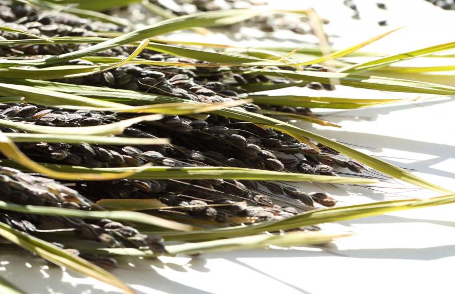
Purple-hued “kodaimai” ancient rice
Gourmet
- 16
-
Tagajo Gourmet Brand, Shiro no Murasaki
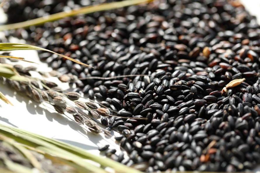
Purple, approaching black in color
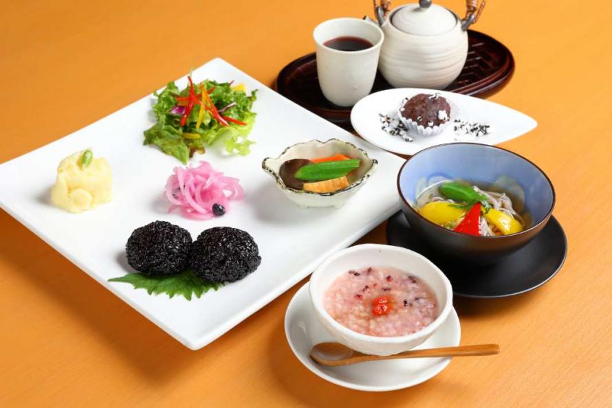
Lunch such as “sakura rice porridge” using ancient rice
Rice has been cultivated in the Tagajo environs since ancient times. In a return to these roots, rice producers today are cultivating ancient rice, known as kodaimai, thought to be similar to the earliest species of rice grown in Japan. This ancient variety, with its beautiful purple hue, has a crackly texture and satisfying chewiness. In addition, it is rich in minerals, vitamins, anthocyanin—a type of polyphenol—and other nutrients, making it popular among people who care about beauty and health. Shiro no Murasaki is the general brand name for gourmet products made using ancient rice, a specialty of the historic city of Tagajo.
Today, restaurants and cafés in Tagajo City serve bread, noodle dishes, and sweets made with ancient rice. In addition, supermarkets and farm stands sell sake and packs of ancient rice. Each product is creatively crafted to highlight the history of Tagajo and the delicious flavor of ancient rice.
Contact: Tagajo City Tourism Association
Address: 2-7-1 Chuo, Tagajo City
Phone: 022-364-5901
Closed: Year-end/New Year holiday (December 29 through January 3 of the following year) *Open from 10:00 a.m. – 4:00 p.m.
Access: At JR Tagajo Station
Website: https://www.tagakan.jp/
*For information on restaurants, please refer to the Tagajo City Tourism Association website.
Tagajo City
Tagajo City is a municipality adjacent to the neighboring city of Sendai. The area has a variety of features, such as stretches of rice paddies reminiscent of ancient Japan, bustling shops along the national highway, and the Teizan Canal—the longest canal in Japan. The canal itself extends from the mouth of the Abukuma River to the former Kitakami River in Ishinomaki City, passing along the coast of Sendai, connecting Shiogama Bay and the coast of Higashi-Matsushima City. Many historical sites can be found in Tagajo City, dating from the prehistoric Jomon Period to modern times, including the Taga Castle Monument, an engraved stone that marks the founding of Taga Castle. Currently, the restoration work is underway on the south gate of Taga Castle in preparation for its opening to the public in 2024, the 1300th anniversary of the castle’s founding (as of March 2023).
The Great East Japan Earthquake, which registered an intensity of 5 upper on the Japanese seismic scale, caused a tsunami that reached approximately 7 meters in height at Sendai Port. A tsunami 2 to 4 meters in height reached Tagajo City, flooding 662 hectares of land, one-third of the total land area of the municipality. Two planned roadways were opened in 2021 as evacuation routes to inland areas in the event of a tsunami—the Shimizusawa–Tagajo road and Kasagami Hachiman road.
Three types of Minato Shiogama Coast Guard Curry
Gourmet
- 17
-
Shiogama City Minato Coast Guard Curry
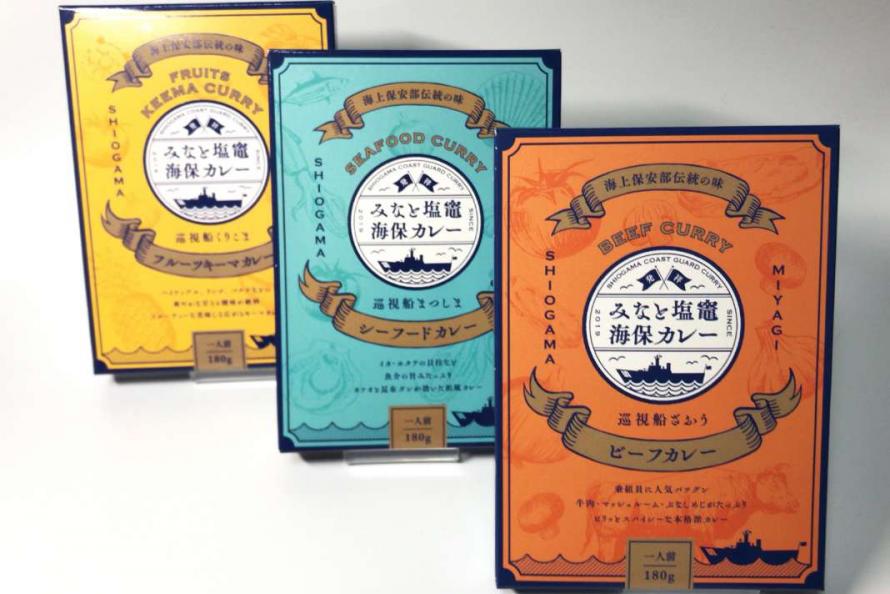
Retort pouch curry
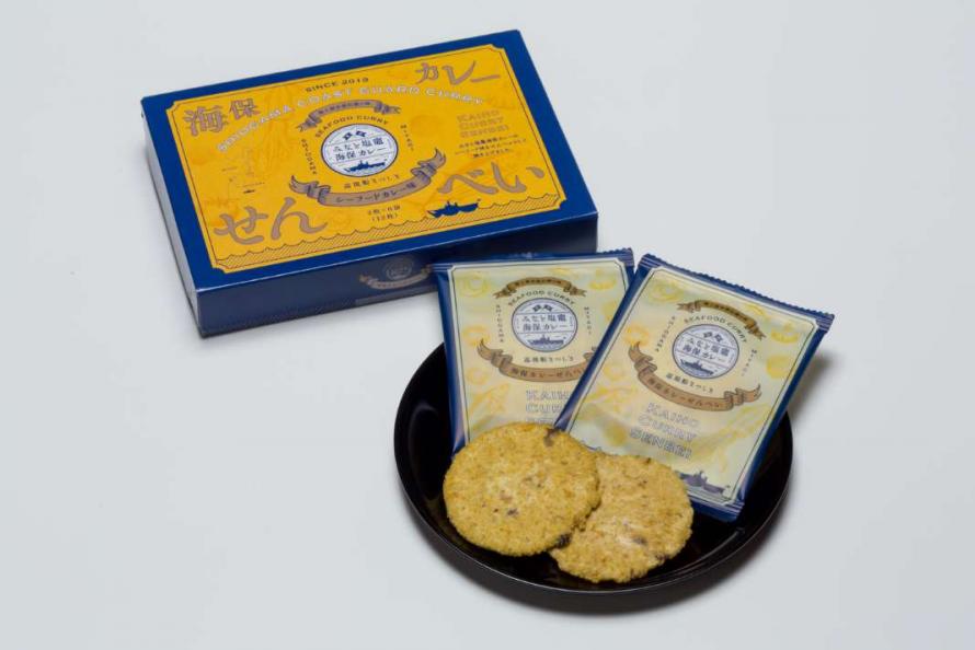
Curry rice crackers
The Miyagi Coast Guard based in Shiogama City has a tradition of serving curry to its personnel on the day of arrival at port, and the curry recipe has been passed down from generation to generation by the chief cook of each ship. With the cooperation of the Miyagi Coast Guard, the curry served on patrol vessels (known as “Minato Shiogama Coast Guard Curry”) has been faithfully reproduced and is now widely available to the public. Visitors can enjoy the curry at eight restaurants around the city. A vacuum-packed retort version can also be purchased. The curry comes in three varieties, each named for a specific patrol vessel—Zao is a beef curry with large chunks of beef and plenty of mushrooms, Matsushima is a Japanese-style seafood curry with the flavor of bonito and kelp as the key ingredients, and Kurikoma is a sweet fruit keema curry made with banana, kiwi, pineapple, and apple. Rice crackers, pies, and cookies have also been developed, with Kaiho Curry Senbei crackers winning an award at the 8th New Tohoku Souvenir Contest.
Contact: Shiogama Chamber of Commerce and Industry
Address: 1-6-20 Minatomachi, Shiogama City
Phone: 022-367-5111
Closed: Saturdays, Sundays, and holidays
Access: About a 10-minute walk from JR Hon-Shiogama Station
Website: http://www.shiogamacci.jp/index.html
* For restaurants, check the Shiogama Chamber of Commerce and Industry website
Shiogama City
The city of Shiogama, which looks out toward Matsushima Bay, includes the Urato Islands (a nationally designated Special Place of Scenic Beauty). The primary industry in Shiogama is fishing, with an annual catch valued at around 9 billion yen. Shiogama is known especially for its fresh tuna, boasting one of the highest catch volumes in Japan. The city is also a leading producer of fish paste products such as kamaboko and is known for its nori seaweed and oysters. In terms of tourism, around 950,000 people annually visit Shiogama Shrine, ranked as Oshu Ichinomiya (one of the major shrines of the Tohoku region), and the Urato Islands also attract people for swimming, hiking, and other outdoor activities.
Besides earthquake damage in the Great East Japan Earthquake, the coastal areas and the Urato area were severely affected by the tsunami, with most residential areas in the Urato area flooded out. The local economy was acutely hurt, with extensive damage to fisheries and fish processing plants, port-related industries, and shallow-water aquaculture.
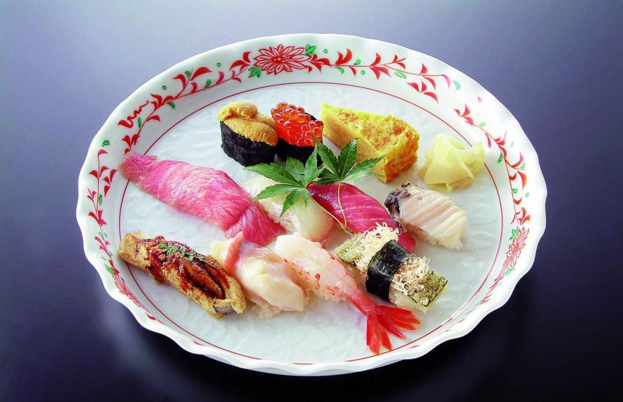
Plateful of Shiogama sushi
Gourmet
- 18
-
Sushi in Shiogama City
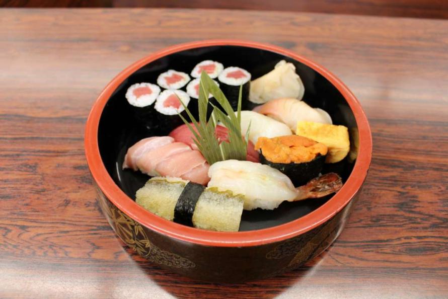
Select sushi with only the freshest seafood
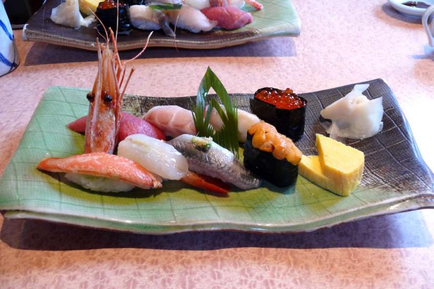
A bowlful of fresh bounty from the sea
Shiogama City is home to numerous sushi restaurants thanks to its rich fishing grounds. You can enjoy sushi prepared with fresh seafood in each season caught off the Sanriku Coast, together with rice from Miyagi, a renowned rice-producing region. The city boasts one of the highest catches of fresh tuna in the country, especially the bigeye tuna caught from September to December, branded as Sanriku Shiogama Higashimono.
Contact: Shiogama City Tourism and Products Association
Phone: 022-362-2525
Shiogama City
The city of Shiogama, which looks out toward Matsushima Bay, includes the Urato Islands (a nationally designated Special Place of Scenic Beauty). The primary industry in Shiogama is fishing, with an annual catch valued at around 9 billion yen. Shiogama is known especially for its fresh tuna, boasting one of the highest catch volumes in Japan. The city is also a leading producer of fish paste products such as kamaboko and is known for its nori seaweed and oysters. In terms of tourism, around 950,000 people annually visit Shiogama Shrine, ranked as Oshu Ichinomiya (one of the major shrines of the Tohoku region), and the Urato Islands also attract people for swimming, hiking, and other outdoor activities.
Besides earthquake damage in the Great East Japan Earthquake, the coastal areas and the Urato area were severely affected by the tsunami, with most residential areas in the Urato area flooded out. The local economy was acutely hurt, with extensive damage to fisheries and fish processing plants, port-related industries, and shallow-water aquaculture.