happiness from the hilltops
Southern Miyagi Prefecture
[ Natori City, Iwanuma City, Watari Town and Yamamoto Town ]
Area Guides
1Natori City Earthquake Reconstruction Museum
Locations of disaster memorials
2Natori City Earthquake Memorial Park
Locations of disaster memorials
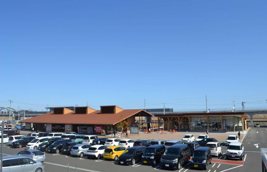
3Kawamachi Terrace, Yuriage
Tourists spots
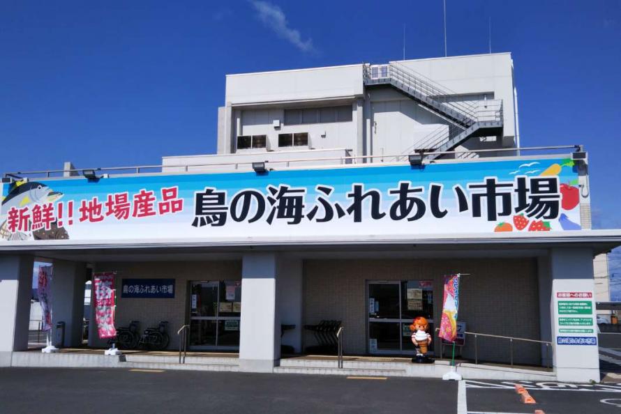
4Yuriage Morning Market/Maple Hall
Tourists spots
5Natori Cycle Sports Center
Tourists spots
6Millennium Hope Hills Exchange Center
Locations of disaster memorials
7Iwanuma Sheep Village
Tourists spots
8Kanahebisui Shrine
Tourists spots
9Watari Onsen Torinoumi
Tourists spots
10Watari B&G Kaiyo Marine Center boathouse
Tourists spots
11Yamamoto Town Ruins of the Great East Japan Earthquake: Nakahama Elementary School
Locations of disaster memorials
12Yamamoto Town Disaster Prevention Base / Yamashita Regional Exchange Center (1F Disaster Prevention Information Corner)
Locations of disaster memorials
13Yamamoto Town Farmer’s and Fisherman’s Market “Yamamoto Yume Ichigo-no-Sato”
Tourists spots
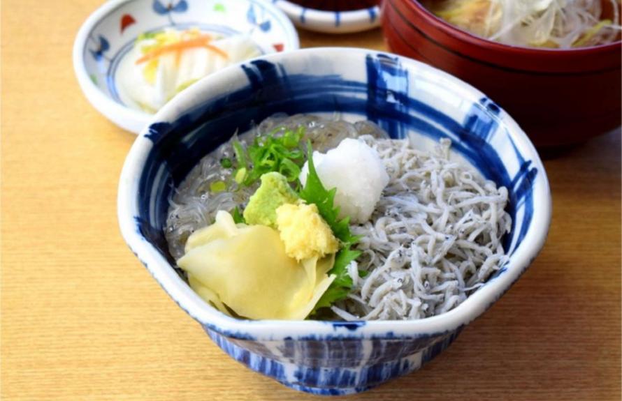
14Natori City Hokugen Shirasu (Whitebait)
Gourmet
15Watari Town/Yamamoto Town Harako Meshi and Hokki Meshi
Gourmet

16Watari Town/Yamamoto Town Strawberries
Gourmet
Diorama that recreates the town of Yuriage
Locations of disaster memorials
- 1
-
Natori City Earthquake Reconstruction Museum
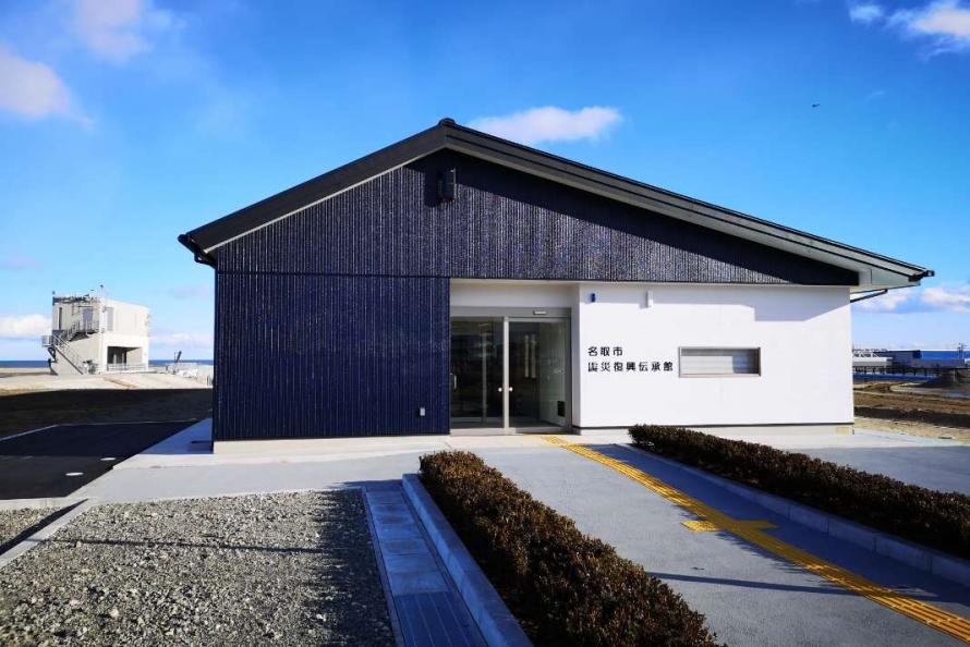
Natori City Earthquake Reconstruction Museum
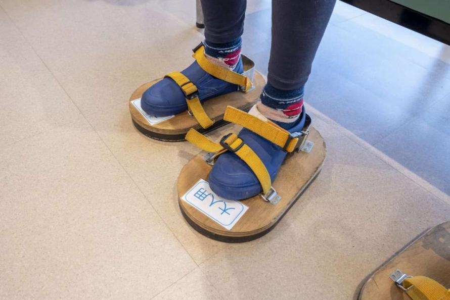
Strap-on sandals that let you feel water pressure
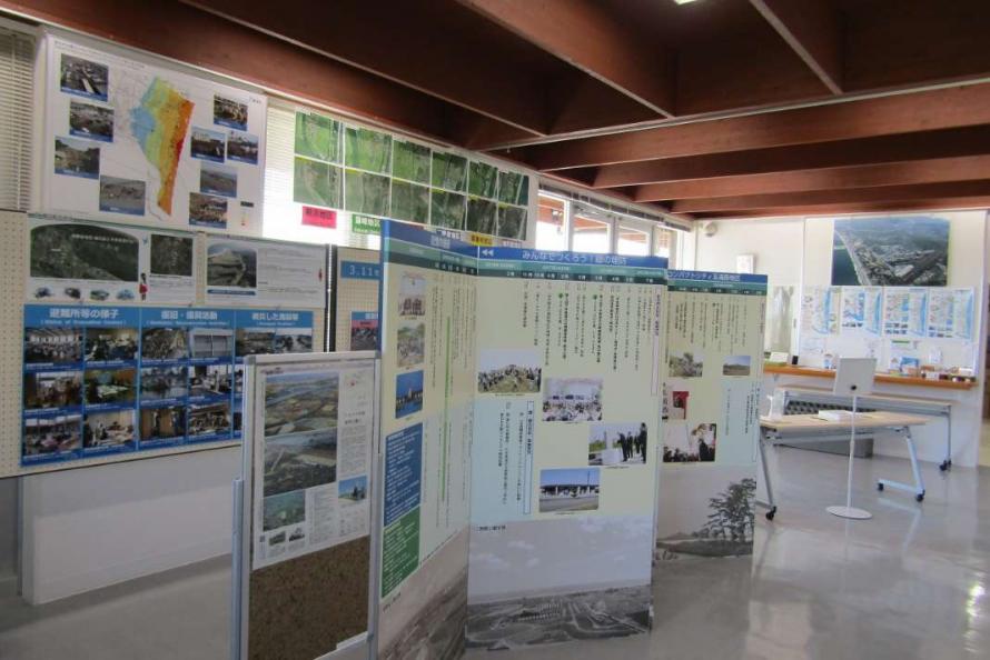
This museum was built to pass on the memories and lessons of the Great East Japan Earthquake and to raise awareness of disaster risk and resilience. At the entrance is a pre-disaster diorama of the town of Yuriage and Natori walking map. The exhibits teach visitors about the area, both present and past. Inside the museum, panels show the process of recovery from the disaster, and the theater room presents videos of the reconstruction and interviews with survivors about the tsunami experience.
One panel exhibit, “The Truth of the Tsunami,” asks the question, “Why did people not try to escape?” It documents the actual experiences of people and offers lessons on disaster survival. The museum also has fun hands-on exhibits that teach visitors about disaster preparedness, such as a door that you try to push open against water pressure and wooden strap-on sandals that let you feel water pressure through your shoes.
A number of facilities are located in the Yuriage area of Natori City along the coast: Natori City Earthquake Reconstruction Museum, Natori City Earthquake Memorial Park, Kawamachi Terrace Yuriage, Yuriage Port Morning Market, and the Natori Cycle Sports Center. The area can be explored on foot or by bicycle, with the Natori City Earthquake Reconstruction Museum at the center.
Language available: English
• There are leaflets in both Japanese and English.
• Videos with English subtitles are available.
Address: 1-1-1 Yuriage-higashi, Natori City
Phone: 022-393-6520
Hours: 9:30 a.m. – 4:30 p.m.
Closed: Tuesdays (the following day if Tuesday is a holiday), year-end/New Year holiday (December 29–January 3)
Admission: Free
Access: About 15 minutes by car from JR Natori Station
Website: https://www.natori-denshoukan.jp/information
Natori City
Located at the entrance to southern Miyagi Prefecture, the city of Natori borders the southern part of Sendai City and stretches from the Pacific Ocean to the hills. The city is conveniently connected to Sendai Station via the Sendai Airport Access Line train, which takes only 15 minutes. Sendai Airport is only 5 minutes away. Because of this rail link convenience, Natori has become a Sendai commuter town, and new housing developments continue to be built, attracting more commercial facilities.
After the Great East Japan Earthquake, the entire coastal area from the Yuriage area to Sendai Airport were struck by the tsunami, resulting in 923 deaths and 38 people missing. A total of 2,801 houses were completely destroyed, and 1,129 were partially damaged*.
*Source: The Great East Japan Earthquake Record of Natori City, as of March 31, 2014 (Natori City)
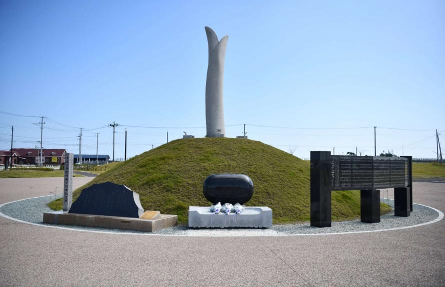
Memorial monument in the shape of a sprout
Locations of disaster memorials
- 2
-
Natori City Earthquake Memorial Park
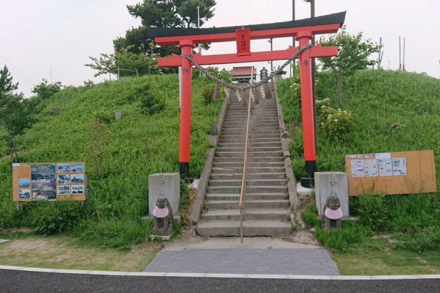
Hiyoriyama and torii gate of the Tominushihime Shrine
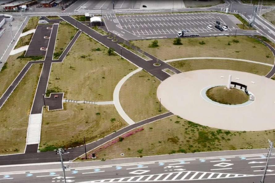
Aerial view of Natori City Earthquake Memorial Park
Located about 5 minutes on foot south of the Natori City Earthquake Reconstruction Museum, the Earthquake Memorial Park consists of the following five zones:
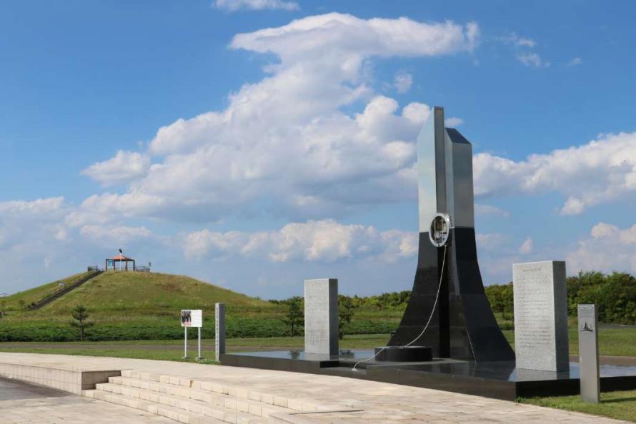
Prayer Zone: A place to offer prayers in memory of those who died in the disaster. The monument at the center, created in the shape of a sprout to symbolize regrowth, stands 8.4 meters tall, the exact height of the tsunami that reached the area.
Rest Zone: A space for local residents to relax at and communicate with other visitors.
Ocean-facing Zone : A zone overlooking Hiroura Bay beyond the levee.
Hiyoriyama Zone: Hiyoriyama, a small hill and landmark of the area for a century, is a symbol of future reconstruction. The Tominushihime Shrine at the top was rebuilt after having been lost in the tsunami.
Remembrance and Memorial Zone: Flat blocks made from earthquake debris are used to show the pre-disaster topography of Yuriage, its roads, the Teizan Canal, and more. Photos transferred onto ceramic tiles show schools, community meeting places and more to help visitors imagine what the Yuriage district was like before the disaster.
A 3.11 Natori-Yuriage memorial event has been held at the Natori City Earthquake Memorial Park and Natori City Earthquake Reconstruction Museum every March 11th since 2015 (except for ceremonies canceled during the COVID-19 pandemic). People make paper lanterns with their own designs and words of prayer on them, bringing them in from around the city or sending them in from all across the country. Heartfelt memorial services are held with these on display lit with candles, along with 3,000 electronic picture lanterns developed by a local electronics manufacturer using solar power and LED lights.
Address: 3-3-1 Yuriage-higashi, Natori City
Phone: 022-393-6520
Admission: Free
Access: About 15 minutes by car from JR Natori Station
Website: https://www.natori-denshoukan.jp/information
Natori City
Located at the entrance to southern Miyagi Prefecture, the city of Natori borders the southern part of Sendai City and stretches from the Pacific Ocean to the hills. The city is conveniently connected to Sendai Station via the Sendai Airport Access Line train, which takes only 15 minutes. Sendai Airport is only 5 minutes away. Because of this rail link convenience, Natori has become a Sendai commuter town, and new housing developments continue to be built, attracting more commercial facilities.
After the Great East Japan Earthquake, the entire coastal area from the Yuriage area to Sendai Airport were struck by the tsunami, resulting in 923 deaths and 38 people missing. A total of 2,801 houses were completely destroyed, and 1,129 were partially damaged*.
*Source: The Great East Japan Earthquake Record of Natori City, as of March 31, 2014 (Natori City)
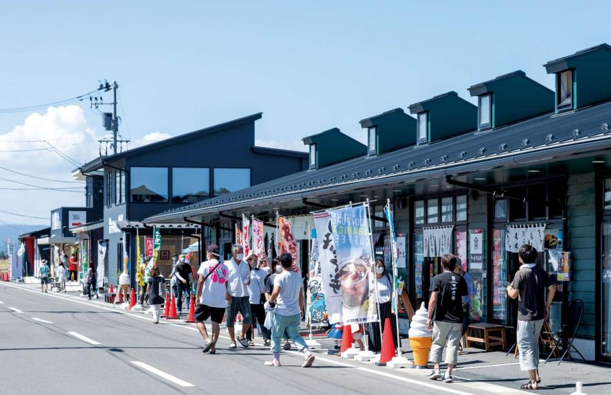
More than 20 shops in the complex
Tourists spots
- 3
-
Kawamachi Terrace, Yuriage
Relaxing spot along the Natori River
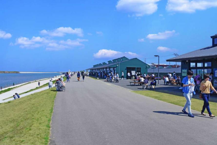
A place for families and tourists to enjoy dining and a stroll
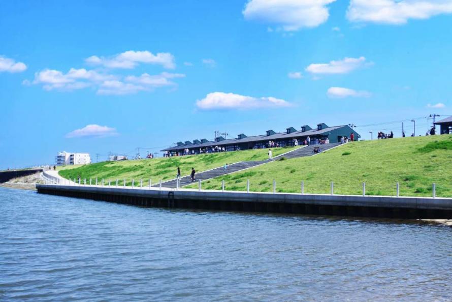
A complex of shops built along the raised embankment of the Natori River, with more than 20 eateries and shops selling seafood, gift products, and more—a symbol of Yuriage’s commercial recovery.
Visitors can enjoy a meal, sweets, or local specialties, and an open terrace offers a view of nearby Yuriage Port, the Sendai cityscape, and the Zao mountains, making it a wonderfully relaxing space for people to enjoy themselves at.
Address: 1-6 Yuriage Chuo, Natori City
Phone: 022-399-6848
Closed: Varies depending on the shop
Admission: Free
Access: About 15 minutes by car from JR Natori Station
Website: https://kawamachi-terasu.jp/
Natori City
Located at the entrance to southern Miyagi Prefecture, the city of Natori borders the southern part of Sendai City and stretches from the Pacific Ocean to the hills. The city is conveniently connected to Sendai Station via the Sendai Airport Access Line train, which takes only 15 minutes. Sendai Airport is only 5 minutes away. Because of this rail link convenience, Natori has become a Sendai commuter town, and new housing developments continue to be built, attracting more commercial facilities.
After the Great East Japan Earthquake, the entire coastal area from the Yuriage area to Sendai Airport were struck by the tsunami, resulting in 923 deaths and 38 people missing. A total of 2,801 houses were completely destroyed, and 1,129 were partially damaged*.
*Source: The Great East Japan Earthquake Record of Natori City, as of March 31, 2014 (Natori City)
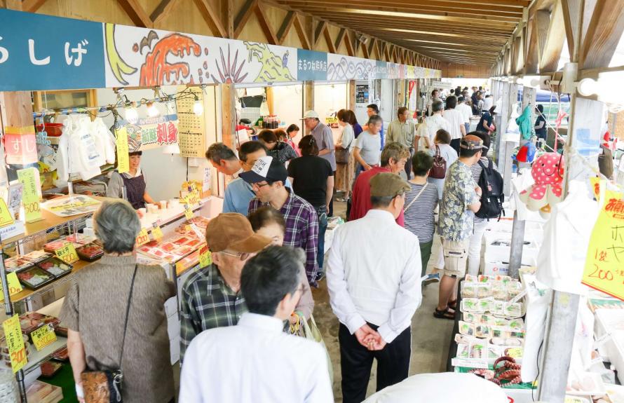
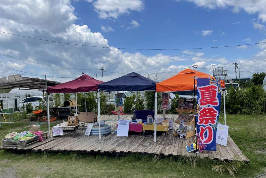
Lively Yuriage Port Morning Market
Tourists spots
- 4
-
Yuriage Morning Market/Maple Hall
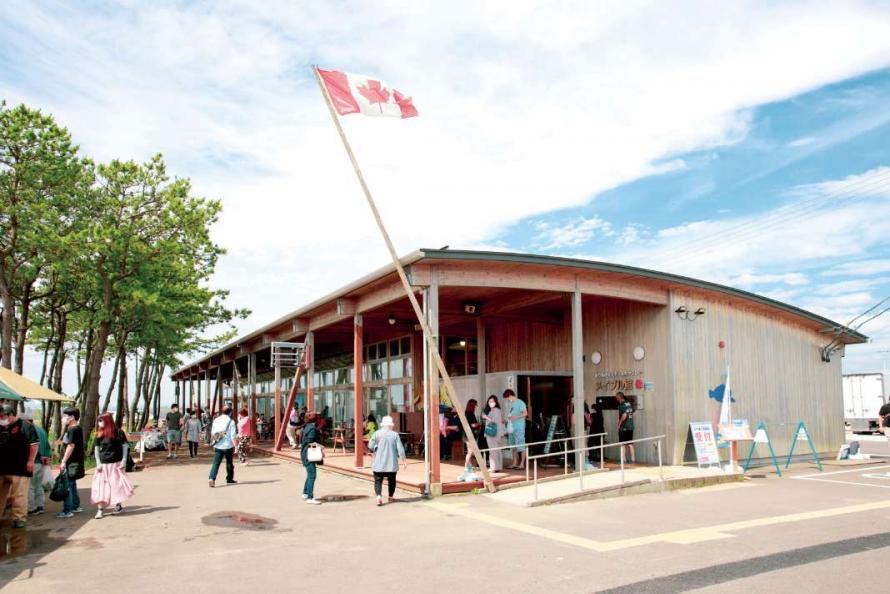
Adjacent Maple Hall
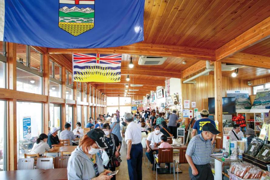
The hall’s food court and souvenir shop
This morning market, held only on Sundays and holidays at the Yuriage fishing port where akagai clams and shirasu (whitebait) are landed, is a popular tourist destination in Natori City. Although the market vendors suffered extensive damage from the Great East Japan Earthquake, they returned to Yuriage in 2013, and today the market has about 40 shops that include the sale of fresh seafood, fresh-picked vegetables, and fresh-cooked meals. The market’s famous auction starts at 10 a.m., open to all comers to experience the lively atmosphere of the auction. Visitors can also buy seafood at the morning market and have it grilled fresh at the adjacent robatayaki grill area to eat on the spot.
A major force behind the area’s rebuilding has been the Canada–Tohoku Reconstruction Project. Led by the national government of Canada, together with the provincial government of British Columbia and the non-profit Canada Wood Group, support was provided to construct buildings made with Canadian timber to help rebuild disaster-affected areas. The adjacent Maple Hall was also built as part of the morning market. The hall is staffed even on weekdays and sells goods that support local reconstruction along with specialty products from Yuriage. Visitors can also enjoy a meal, watch a video that conveys memories of the disaster, or make an appointment to hear a storytelling lecture or talk by a disaster preparedness lecturer.
Address: 3-5-1 Yuriage-higashi, Natori City
Phone: 022-395-7211
< Yuriage Port Morning Market >
Hours: 6:00 a.m. – 1:00 p.m.
Closed: Weekdays and Saturdays; only open on Sundays and public holidays
Admission: Free
< Maple Hall >
Hours: Monday to Saturday 10:00 a.m. – 4:00 p.m., Sundays and public holidays 6:00 a.m. – 1:00 p.m.
Closed: Weekdays and Saturdays; only open on Sundays and public holidays
Admission: Free
Access: About 15 minutes by car from JR Natori Station
Website: https://www.yuriageasaichi.jp/
Natori City
Located at the entrance to southern Miyagi Prefecture, the city of Natori borders the southern part of Sendai City and stretches from the Pacific Ocean to the hills. The city is conveniently connected to Sendai Station via the Sendai Airport Access Line train, which takes only 15 minutes. Sendai Airport is only 5 minutes away. Because of this rail link convenience, Natori has become a Sendai commuter town, and new housing developments continue to be built, attracting more commercial facilities.
After the Great East Japan Earthquake, the entire coastal area from the Yuriage area to Sendai Airport were struck by the tsunami, resulting in 923 deaths and 38 people missing. A total of 2,801 houses were completely destroyed, and 1,129 were partially damaged*.
*Source: The Great East Japan Earthquake Record of Natori City, as of March 31, 2014 (Natori City)
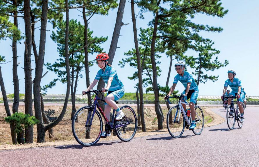
4 km cycling circuit
Tourists spots
- 5
-
Natori Cycle Sports Center
Lodging facility Natori Yuriage Onsen “Rinrin- no-Yado Guesthouse”
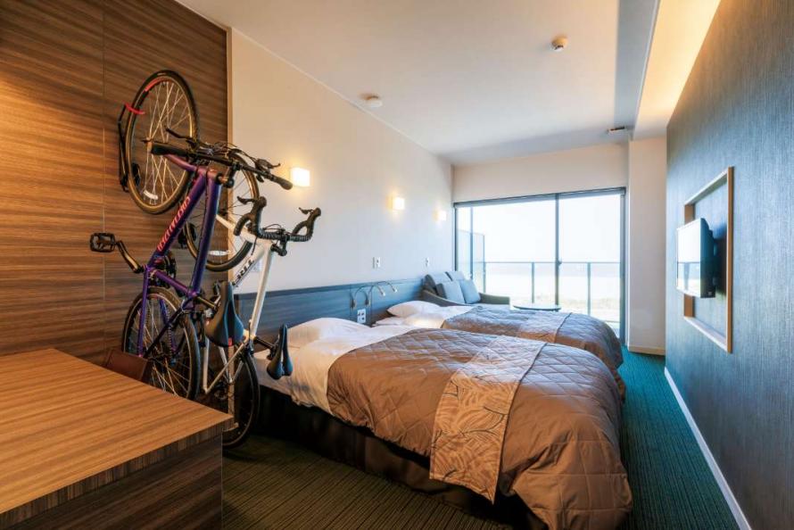
Bicycle-friendly rooms
This sports park and hot spring lodging facility is located east of Natori City Earthquake Memorial Park, across the Hirourabashi Bridge. The cycling center that originally existed at this location was wiped out by the tsunami and finally rebuilt nine and a half years later. A four-kilometer cycling circuit along the Yuriage coastline allows visitors to enjoy a light ride in view of the ocean.
Various types of rental bicycles are available, and there are also two 3-on-3 basketball courts, a skateboard park, futsal court, and playground for children.
A natural underground hot spring was discovered when rebuilding the park, so the Rinrin-no-Yado Guesthouse lodging facility was added. The lodging’s hot spring facilities can also be used by non-staying guests, a great way to refresh oneself after physical exertion. It is also an ideal facility for training camps.
Address: 2-20 Higashisuka, Yuriage, Natori City
Phone: 022-385-8027
Hours: 9:00 a.m. – 5:00 p.m.
Closed: Wednesdays for outdoor facilities (except during summer holidays); second Wednesday of the month for hot springs and other facilities
Admission: Fee required (see the facility’s website for details)
*Rental bicycles and usage fees for other facilities are charged separately.
Access: About 15 minutes by car from JR Natori Station
About 13 minutes by car from Sendai Airport
Website: https://www.natori-cycle.com/en/
Natori City
Located at the entrance to southern Miyagi Prefecture, the city of Natori borders the southern part of Sendai City and stretches from the Pacific Ocean to the hills. The city is conveniently connected to Sendai Station via the Sendai Airport Access Line train, which takes only 15 minutes. Sendai Airport is only 5 minutes away. Because of this rail link convenience, Natori has become a Sendai commuter town, and new housing developments continue to be built, attracting more commercial facilities.
After the Great East Japan Earthquake, the entire coastal area from the Yuriage area to Sendai Airport were struck by the tsunami, resulting in 923 deaths and 38 people missing. A total of 2,801 houses were completely destroyed, and 1,129 were partially damaged*.
*Source: The Great East Japan Earthquake Record of Natori City, as of March 31, 2014 (Natori City)
Millennium Hope Hills Exchange Center
Locations of disaster memorials
- 6
-
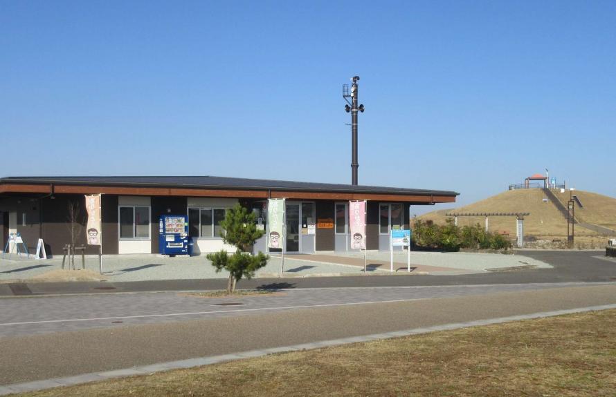
Millennium Hope Hills Exchange Center
Monument and Hills
Exchange Center Exhibition Space
Millennium Hope Hills is a memorial park and symbol of reconstruction, created with the hope that children will be able to live happily with smiles on their faces for a thousand years to come. The park is a place for mourning, transmitting the legacy of the disaster, and educating people about risk and preparedness. In total, there are six parks along a 10-kilometer stretch of coastline that retain the names of pre-disaster villages (Ainokama, Fujisone, Ninokura, Hasegama, Kabasaki, and Shinbama), plus connecting park roads and related facilities. The hills were constructed by recycling approximately 90% of the city’s disaster debris, totaling about 574,000 tons. Millennium Hope Hills is part of a “multi-layered” tsunami defense system that starts with a seawall and heads inland, with the Hills, shoreline protection on the Teizan Canal, and the Tamaura Hope Line raised roads. Since 2013, volunteers have planted nearly 400,000 trees of 21 different species. The goal for these trees to grow into a magnificent coastal forest and natural barrier to protect the residents of the city in 15 to 20 years.
Ainokama Park, located approximately 800 meters from Sendai Airport, has an exchange center that serves as a disaster education facility, plus a memorial monument, evacuation hill, open-air plaza, and preserved ruins from the disaster, including a fire lookout tower and the foundations of lost homes. The exchange center presents photographs, panel displays, and video footage that provide an in-depth record of the great tsunami and the lessons that can be learned, showing also the progress being made in reconstruction. Visitors can make a reservation to listen to a talk given by a storyteller (fees required), or rent bicycles to visit the six parks, preserved ruins, and related facilities.
There are “evacuation hills” at each park, 14 in total, each equipped with a gazebo at the top that can be converted into a large tent to shelter evacuees with benches that turn into barbecue pits in case of emergency, and hold supplies including phone chargers (with solar lights) and more.
Languages available: English, Chinese (simplified), Chinese (traditional), Korean
• Some video materials have subtitles in English, Chinese (simplified), Chinese (traditional), and Korean.
• An explanatory booklet (free) is available in English, Chinese (simplified), Chinese (traditional), and Korean.
• Some exhibits provide explanations in both Japanese and English.
Address: 177 Hama, Shimonogo, Iwanuma City
Phone: 0223-23-8577
Hours: 9:00 a.m. – 5:00 p.m.
Closed: Tuesdays (the following day if Tuesday is a holiday), year-end/New Year holiday
Admission: Free for general viewing
*A fee is required to rent out the entire exchange space.
Access: About 20 minutes by car from JR Iwanuma Station
About 10 minutes by car from Iwanuma IC on the Sendai-Tobu Road
About 7 minutes by car from Sendai Airport IC
About a 17-minute walk from Sendai Airport
Website: https://sennen-kibouno-oka.com/english/
Iwanuma City
The city of Iwanuma is located at the mouth of the Abukuma River, which flows south through the Sendai Plain. The area is blessed with abundant nature and a mild climate. Iwanuma City has long been a major transportation hub due to the confluence of transportation routes. Today, it has the Sendai-Tobu Road, National Routes 4 and 6, and the JR Tohoku Main Line and Joban Line for rail transport. Sendai Airport belongs to both cities of Iwanuma and Natori. Together, these modes of transportation have contributed to thriving commerce and industry. Many tourists also come to visit the Takekoma Shrine, one of the three great Inari shrines in Japan, and Kanahebisui Shrine, believed to bring good fortune and business prosperity.
The tsunami due to the Great East Japan Earthquake flooded approximately 48% of the city, the highest percentage among coastal cities and towns. Agricultural land suffered damage from debris and seawater salt, two industrial parks were almost entirely destroyed, and the entire Sendai Airport was flooded—all contributing to significant damage to the local economy and industries.
Feeding the sheep
Tourists spots
- 7
-
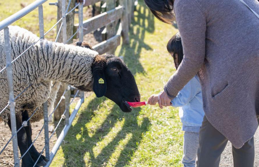
Iwanuma Sheep Village
Sheep ranch
Various events are held seasonally
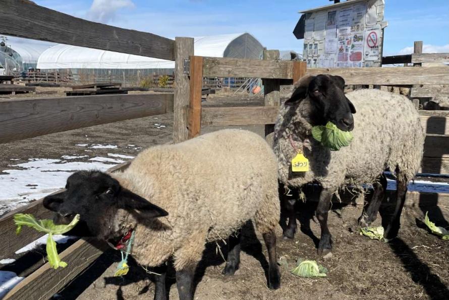
This complex features a sheep ranch, agricultural fields, open-air plaza, and dog run area, located adjacent to Ninokura Park at Millennium Hope Hills. It was created through a collaboration between the city of Iwanuma and the Japan Overseas Cooperation Association (JOCA), utilizing a former village site that was designated a disaster risk zone. It is one of many initiatives being carried out to make effective use of the coastal area to create opportunities for interaction, give people a sense of purpose, and prevent the memory of the disaster from fading.
Sheep are allowed to graze to keep weeds under control and keep grassy areas tidy. The ranch and its gazebo are designed to encourage community interaction. Visitors can feed the sheep, harvest vegetables, and experience handicrafts using sheep’s wool. Various events are also held seasonally.
Address: 61 Sukahara, Oshiwake, Iwanuma City (Ninokura area)
Phone: 080-4105-5538
Hours: 10:00 a.m. – 4:00 p.m. (until 3:00 p.m. from December to the end of January)
Closed: Open all year round (may be closed due to inclement weather or other weather conditions)
Admission: Fee required (see the facility’s website for details)
Access: About 15 minutes by car from JR Iwanuma Station
About 7 minutes by car from Iwanuma IC on the Sendai-Tobu Road
About 20 minutes by bicycle rented from the Exchange Center
Website: https://iwanumahitsuji.jp
Iwanuma City
The city of Iwanuma is located at the mouth of the Abukuma River, which flows south through the Sendai Plain. The area is blessed with abundant nature and a mild climate. Iwanuma City has long been a major transportation hub due to the confluence of transportation routes. Today, it has the Sendai-Tobu Road, National Routes 4 and 6, and the JR Tohoku Main Line and Joban Line for rail transport. Sendai Airport belongs to both cities of Iwanuma and Natori. Together, these modes of transportation have contributed to thriving commerce and industry. Many tourists also come to visit the Takekoma Shrine, one of the three great Inari shrines in Japan, and Kanahebisui Shrine, believed to bring good fortune and business prosperity.
The tsunami due to the Great East Japan Earthquake flooded approximately 48% of the city, the highest percentage among coastal cities and towns. Agricultural land suffered damage from debris and seawater salt, two industrial parks were almost entirely destroyed, and the entire Sendai Airport was flooded—all contributing to significant damage to the local economy and industries.
Main hall of the shrine
Tourists spots
- 8
-
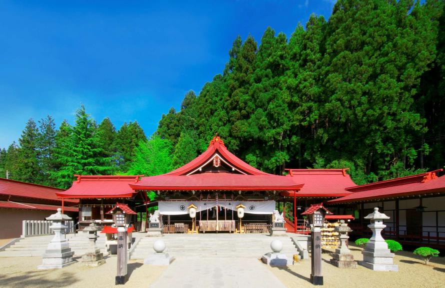
Kanahebisui Shrine
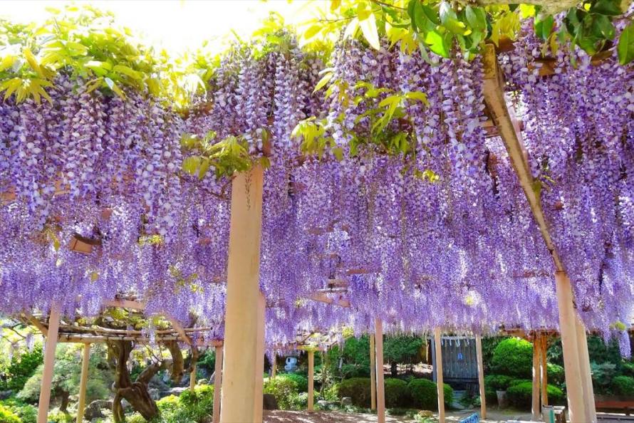
Large wisteria trellis after passing through the torii gate
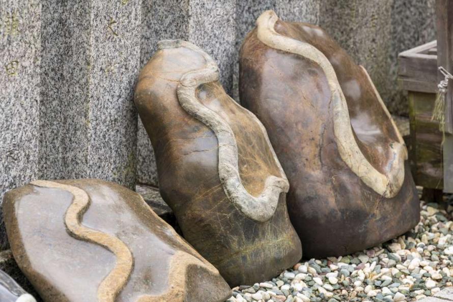
Stroking a snake-patterned stone with your hand or wallet
brings good fortune
Located about 10 minutes by car inland from JR Iwanuma Station, this ancient shrine is dedicated to dragons and snakes, which are considered the embodiments of water gods and widely worshipped as guardian deities of wealth, vitality, and livelihood. When you pass through the torii gate, there is a large wisteria trellis, and the garden is known for its beautiful peonies and azaleas. A flower festival and annual festival are held every year from early to mid-May when these flowers are in full bloom and the area becomes very lively.
Lined up on the south side of the shrine are stones with snake patterns that are completely natural. It is said that if one of these stones catches your attention and you choose it intuitively and stroke the pattern with your hand or wallet, your financial fortune will improve.
A facility built in the outer garden of the shrine—Sando Terrace—has won awards for its architectural design reminiscent of a snake’s body. It features a rest area, souvenir shop, restaurant, and café terrace popular with visitors.
Address: 7 Suijin, Miiroyoshi, Iwanuma City
Phone: 0223-22-2672
Admission: Free for worship
Fee is required for the peony garden during the Flower Festival (see the facility’s website for details)
Access: About 10 minutes by car from JR Iwanuma Station
About 20 minutes by car from Murata IC on the Tohoku Expressway
About 10 minutes by car from Sendai Airport IC on the Sendai-Tobu Road and about 15 minutes by car from Iwanuma IC
Website: http://kanahebi.cdx.jp
Iwanuma City
The city of Iwanuma is located at the mouth of the Abukuma River, which flows south through the Sendai Plain. The area is blessed with abundant nature and a mild climate. Iwanuma City has long been a major transportation hub due to the confluence of transportation routes. Today, it has the Sendai-Tobu Road, National Routes 4 and 6, and the JR Tohoku Main Line and Joban Line for rail transport. Sendai Airport belongs to both cities of Iwanuma and Natori. Together, these modes of transportation have contributed to thriving commerce and industry. Many tourists also come to visit the Takekoma Shrine, one of the three great Inari shrines in Japan, and Kanahebisui Shrine, believed to bring good fortune and business prosperity.
The tsunami due to the Great East Japan Earthquake flooded approximately 48% of the city, the highest percentage among coastal cities and towns. Agricultural land suffered damage from debris and seawater salt, two industrial parks were almost entirely destroyed, and the entire Sendai Airport was flooded—all contributing to significant damage to the local economy and industries.
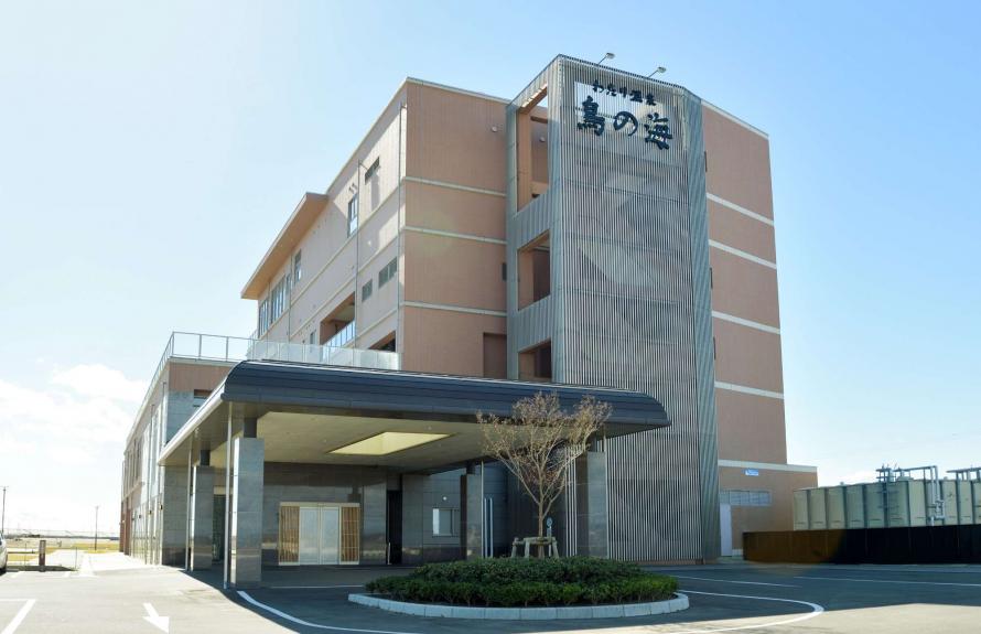
Watari Onsen Torinoumi
Tourists spots
- 9
-
Watari Onsen Torinoumi
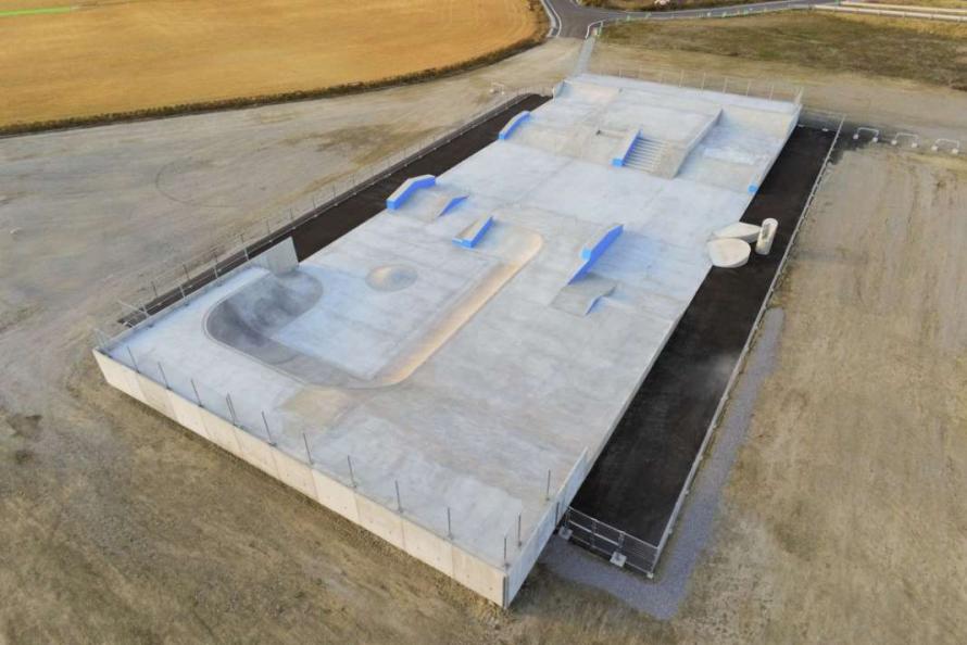
Skateboard park in Torinoumi Park
Torinoumi Fureai Market
The brackish water lake Torinoumi faces the Pacific Ocean and is a habitat for wild birds, including migratory birds and seabirds. Watari Onsen Torinoumi is a relaxing hot spring lodging that offers a natural seaside hot spring bath with long-known skin-beautifying effects. The top floor features an open-air bath where you can feel the sea breeze, as well as an indoor large bath overlooking the Pacific Ocean. The top floor has an ocean-view restaurant that serves fresh seafood and local cuisine. Within walking distance is Torinoumi Park, rebuilt after the disaster, which includes an evacuation hill, track and athletic field, soccer field, baseball field, skateboard park, and multi-purpose field. Visitors can also walk to Watari Arahama Beach, Torinoumi Fureai Market, and Arahama Nigiwai Kairo Shopping Street. There are many ways to enjoy the area, whether sightseeing or as part of sports training camp.
Address: 41-2 Chikkodori, Arahama, Watari Town, Watari District
Phone: 0223-35-2744
Hours: Non-staying guest bathing: 10:00 a.m. – 8:00 p.m. (last admission at 7:30 p.m.)
Closed: Open all year round
Admission: Fee required (see the facility’s website for details)
Access: About 20 minutes by car from JR Watari Station or Sendai Airport Station on the Sendai Airport Access Line
About 5 minutes by car from Torinomi Smart IC on the Sendai Tobu Road
Website: http://www.torinoumi.com/
Watari Town
The town of Watari is located in the southern part of Miyagi Prefecture, bordered by the Abukuma River to the north, the Pacific Ocean to the east, and the Abukuma Highlands to the west. The town is blessed with a beautiful natural environment and enjoys mild winters and cool summers. The local economy is mainly based on agriculture, particularly rice cultivation, as well as greenhouse horticulture and fruit growing, which are all well-suited to the geographical conditions. Watari Town boasts the largest strawberry production in the Tohoku region, and the town also has thriving fisheries and manufacturing. Plus, Watari Town is known for its traditional local dish, harako meshi, which has a 400-year history.
The tsunami flooded around 35 square kilometers, approximately 48% of the town’s total area. There was a severe impact not only on fisheries but also on farmland and agricultural facilities, with rice cultivation forced to be suspended due to salt damage. About 93% of the strawberry farmers were also affected, devastating this fresh produce, as well.
Torinoumi Park in the Arahama area, which was hard hit by the tsunami, lost all of its facilities, including a track and athletic field and playground equipment. However, a reconstruction project was completed in August 2021 and the park was reopened as a 27-hectare comprehensive park featuring an artificial turf soccer field, baseball field, and multi-purpose open field area.
In addition, a new street-style skateboard park was built at the park, attracting people from both inside and outside of the town and creating a lively atmosphere.
Kayaking experience
Tourists spots
- 10
-
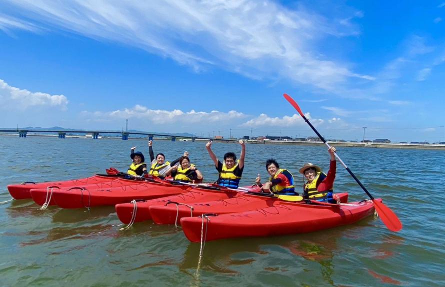
Watari B&G Kaiyo Marine Center boathouse
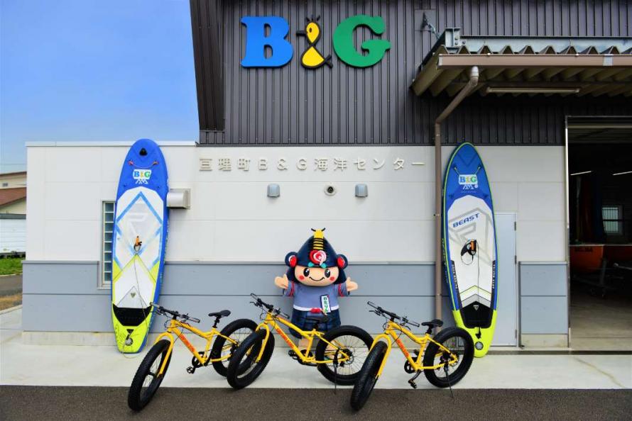
Watari B&G Kaiyo Marine Center boathouse
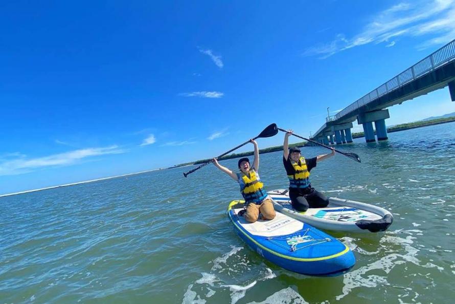
SUP experience
Located 5 minutes by car or 20 minutes on foot from Watari Onsen Torinoumi, this marine leisure center is a place where anyone can enjoy marine sports without bringing any equipment. The boathouse was completely destroyed by the tsunami but was rebuilt in May 2018. Its pet-friendly kayaks have become especially popular on social media. When the sea is rough, tours of the coastal area by motorbike or bicycle are available. The center also offers a “ocean school” for children along with safety classes and events to familiarize people with the sea.
Marine sports that can be experienced: SUP, boating, kayaking , etc.
Address: 7-6 Arahama-torinoumi, Watari Town, Watari District
Phone: 0223-33-2210
Hours: 10:00 a.m. – 5:00 p.m. (last admission at 4:00 p.m.)
Closed: Mondays and Tuesdays
Fees: Fee required (see the facility’s website for details)
Access: About 15 minutes by car from JR Watari Station
About 20 minutes by car from Sendai Airport Access Line Sendai Airport Station
Website: https://watari-bg.com/
Watari Town
The town of Watari is located in the southern part of Miyagi Prefecture, bordered by the Abukuma River to the north, the Pacific Ocean to the east, and the Abukuma Highlands to the west. The town is blessed with a beautiful natural environment and enjoys mild winters and cool summers. The local economy is mainly based on agriculture, particularly rice cultivation, as well as greenhouse horticulture and fruit growing, which are all well-suited to the geographical conditions. Watari Town boasts the largest strawberry production in the Tohoku region, and the town also has thriving fisheries and manufacturing. Plus, Watari Town is known for its traditional local dish, harako meshi, which has a 400-year history.
The tsunami flooded around 35 square kilometers, approximately 48% of the town’s total area. There was a severe impact not only on fisheries but also on farmland and agricultural facilities, with rice cultivation forced to be suspended due to salt damage. About 93% of the strawberry farmers were also affected, devastating this fresh produce, as well.
Torinoumi Park in the Arahama area, which was hard hit by the tsunami, lost all of its facilities, including a track and athletic field and playground equipment. However, a reconstruction project was completed in August 2021 and the park was reopened as a 27-hectare comprehensive park featuring an artificial turf soccer field, baseball field, and multi-purpose open field area.
In addition, a new street-style skateboard park was built at the park, attracting people from both inside and outside of the town and creating a lively atmosphere.
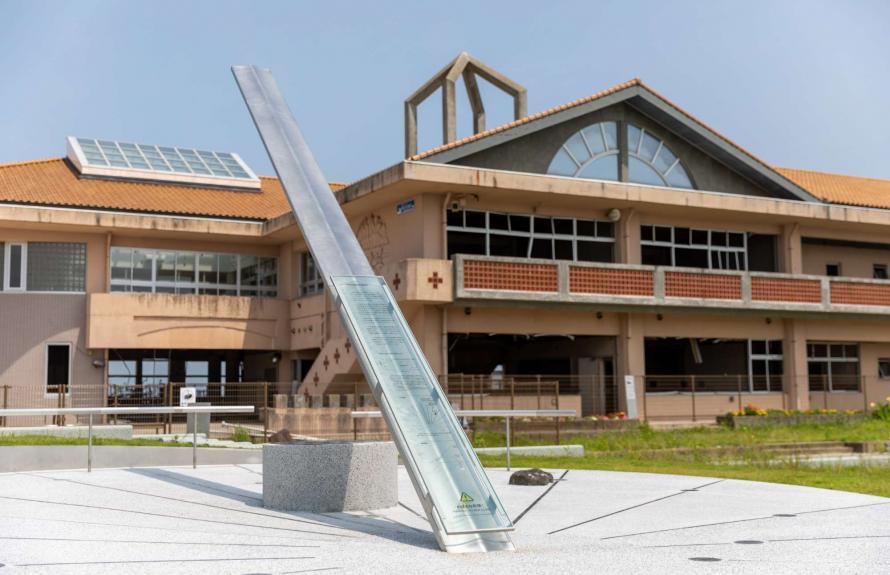
Yamamoto Town Ruins of the Great East Japan Earthquake: Nakahama Elementary School
Locations of disaster memorials
- 11
-
Yamamoto Town Ruins of the Great East Japan Earthquake: Nakahama Elementary School
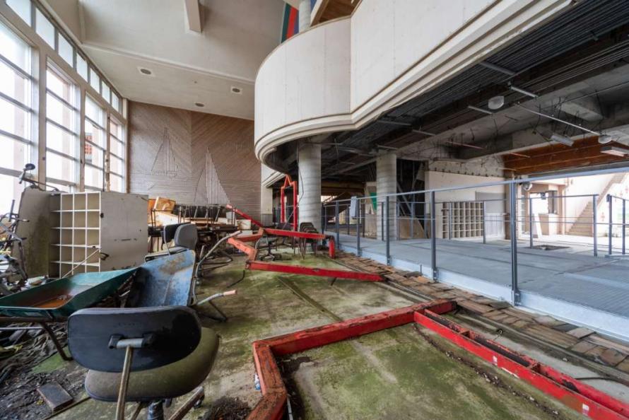
Debris scattered on the first floor of the school building
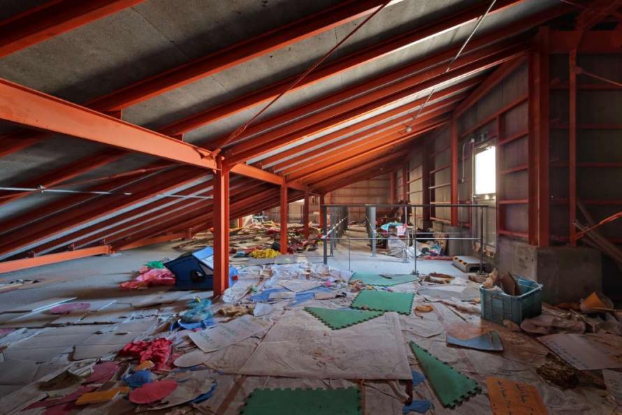
The attic warehouse where children and local residents spent the night
The Nakahama Elementary School has been preserved as it was at the time of the disaster, serving as the only earthquake memorial in the southern part of the prefecture.
The school building stands 400 meters from the coastline. Shortly after the earthquake, 90 people, including students and local residents who had evacuated to the school, were inside the building. As the arrival time of the expected tsunami approached, the principal chose to evacuate everyone to the rooftop of the school building rather than moving everyone inland to a designated evacuation center. The tsunami nearly reached the second-floor ceiling, isolating Nakahama Elementary School in the tsunami sea, but all 90 people were safe on the rooftop.
Visitors can enter the damaged school building, see the attic warehouse where children and local residents spent the night, listen to storytellers recount memories and the traces of the tsunami, or watch video footage taken at the time. The facility promotes learning about the importance of vigilance and disaster preparedness.
Decisions about how to preserve the site and how to design it as a memorial and educational facility went through a careful process of discussion involving residents, teachers, and experts. Elements including the sundial monument in front that gets visitors to think about and feel the passage of time were brought together into an integrated design that has won high praise. For both the design and the process, the site received the Good Design Award in 2020 (sponsored by the Japan Institute of Design Promotion) and the Good Design Best 100 award for best design practice excellence. At an online award ceremony, it was later awarded a Good Focus Award in the category of Disaster Prevention and Reconstruction Design, making it a double winner.
Language available: English
• The leaflet is available in both Japanese and English.
• Some exhibits are available in both English and Japanese.
• A video with English subtitles (12-13 minutes) is available.
• An English handbook is available for a fee.
Address: 22-2 Kune, Sakamoto, Yamamoto Town, Watari District
Phone: 0223-23-1171
Hours: 9:30 a.m. – 4:30 p.m. (last admission at 4:00 p.m.)
Closed: Mondays (the following day if Monday is a holiday), December 28–January 4
Admission: Fee required (see the facility’s website for details)
Access: About a 25-minute walk from Sakamoto Station on the JR Joban Line
(Rental bicycles are also available at Sakamoto Station and at Yamamoto Yume Ichigo-no-Sato.)
About 10 minutes by car from the Yamamoto Minami Smart IC on the Joban Expressway
Website: https://www.town.yamamoto.miyagi.jp/site/ruins-nakahama/
Yamamoto Town
Yamamoto Town is located at the southeastern end of Miyagi Prefecture along the Pacific Ocean with the Abukuma Highlands to the west. The town has a mild climate and plenty of natural greenery and is blessed with abundance from the sea, mountains, and countryside. Yamamoto’s main industry is agriculture; the town is one of the largest producers of strawberries and apples in the prefecture. It is also known for Shine Muscat grapes and surf clams, seasonal specialties for visitors to enjoy.
The tsunami due to the Great East Japan Earthquake inundated 24 square kilometers, equivalent to 37.2% of the town’s total area. Debris covered the land from the coast to National Route 6; 77.8% of farmland was affected, and 90% of strawberry cultivation facilities were destroyed. Damage to lifelines and transportation facilities was also extensive. The railroad tracks south of Yamashita Station on the JR Joban Line were washed out, and major roads along the coast were destroyed or made impassable. The town’s only fishing port, Isohama Fishing Port, ceased to function due to the destruction of its access road and breakwater. In addition, food-related and metal-related factories were either completely or partially destroyed, causing devastating damage to the town’s industrial base.
Yamamoto Town Disaster Prevention Base / Yamashita Regional Exchange Center
Locations of disaster memorials
- 12
-
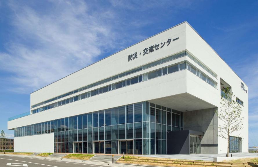
Yamamoto Town Disaster Prevention Base / Yamashita Regional Exchange Center (1F Disaster Prevention Information Corner)
(Tsubamenomori Hidamari Hall)
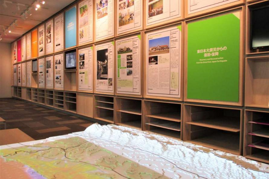
1st Floor Disaster Prevention Information Corner
(videos, dioramas, panels, etc.)
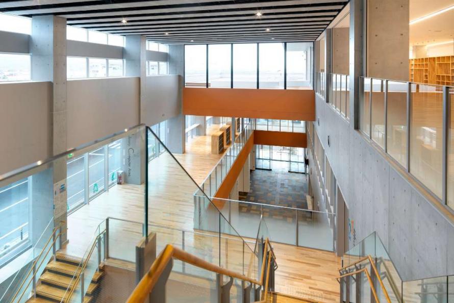
A hub to promote regional involvement and vitality
This facility combines two functions—ensuring safety as a community base for disaster resilience and creating a hub to promote regional involvement and vitality. It is also designed to serve as an evacuation center and has space to shelter 700-800 evacuees during emergencies. Having learned from the disaster, the facility was equipped with a private power generation system, earthquake-resistant water storage tanks (for 40 metric tons of drinking water), and eight “manhole toilets” for emergency use.
On the first floor is a Disaster Prevention Information Corner that displays materials related to the Great East Japan Earthquake aimed at passing on memories and records of the natural disaster and raising awareness of disaster prevention measures and mitigation efforts involving a tsunami or other emergency. Visitors can also learn about the reconstruction efforts on Yamamoto Town’s new town center area, leading up to its completion.
Address: 1-8 Tsubamenomori, Yamamoto Town, Watari District
Phone: 0223-37-5592
Hours: 9:00 a.m. – 9:30 p.m.
Closed: December 28–January 4 (other temporary closures may occur)
Admission: Free for viewing
Access: About a 1-minute walk from Yamashita Station on the JR Joban Line
About 5 minutes by car from the Yamamoto IC on the Joban Expressway
About 15 minutes by car from the Yamamoto Minami Smart IC on the Joban Expressway
Website: https://www.town.yamamoto.miyagi.jp/soshiki/20/8035.html
Yamamoto Town
Yamamoto Town is located at the southeastern end of Miyagi Prefecture along the Pacific Ocean with the Abukuma Highlands to the west. The town has a mild climate and plenty of natural greenery and is blessed with abundance from the sea, mountains, and countryside. Yamamoto’s main industry is agriculture; the town is one of the largest producers of strawberries and apples in the prefecture. It is also known for Shine Muscat grapes and surf clams, seasonal specialties for visitors to enjoy.
The tsunami due to the Great East Japan Earthquake inundated 24 square kilometers, equivalent to 37.2% of the town’s total area. Debris covered the land from the coast to National Route 6; 77.8% of farmland was affected, and 90% of strawberry cultivation facilities were destroyed. Damage to lifelines and transportation facilities was also extensive. The railroad tracks south of Yamashita Station on the JR Joban Line were washed out, and major roads along the coast were destroyed or made impassable. The town’s only fishing port, Isohama Fishing Port, ceased to function due to the destruction of its access road and breakwater. In addition, food-related and metal-related factories were either completely or partially destroyed, causing devastating damage to the town’s industrial base.
Yamamoto Town Farmer’s and Fisherman’s Market “Yamamoto Yume Ichigo-no-Sato”
Tourists spots
- 13
-
Yamamoto Town Farmer’s and Fisherman’s Market “Yamamoto Yume Ichigo-no-Sato”
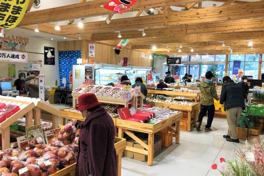
Interior of the shop lined with fresh agricultural and seafood products
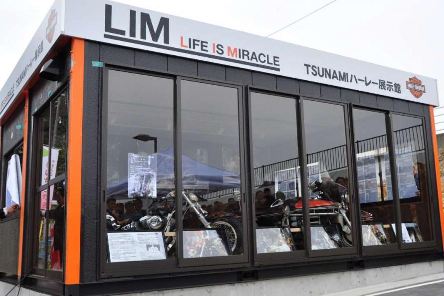
Tsunami Harley Exhibition Hall
This farmer’s market sells local Yamamoto specialties direct to visitors—items such as strawberries, apples, surf clams, Shine Muscat grapes, and other fresh agricultural and seafood products, as well as processed goods made from local ingredients.
In addition, the commercial facility also serves as a general information center for the community, providing introductions to and taking reservations for local farms during the strawberry picking season. It also offers various kinds of sightseeing information plus free rental bicycles to explore the surrounding area.
There are three restaurants in the adjacent food court serving Japanese, Western, or Chinese food to give visitors a choice and a chance to try seasonal cuisine and dishes made from local ingredients.
A “Tsunami Harley Exhibition Hall” is also located on the site, displaying a U.S.-made Harley-Davidson motorcycle that was damaged in the town in the Great East Japan Earthquake. It also has a photo exhibit of the “miracle Harley” that drifted across the Pacific Ocean from Yamamoto Town to Canada after being drawn out to sea, conveying the danger of a tsunami.
Address: 183-1 Arai, Sakamoto, Yamamoto Town, Watari District
Phone: 0223-38-1888
Hours: Market 9:30 a.m. – 5:00 p.m.
Food court business hours vary depending on the shop.
Closed: Year-end/New Year holiday (December 31–January 2)
Access: About a 1-minute walk from Sakamoto Station on the JR Joban Line
About 5 minutes by car from the Sendai-Tobu Road & Yamamoto Minami Smart IC on the Joban Expressway
Website: https://yumeichigo.jp/index.html
Yamamoto Town
Yamamoto Town is located at the southeastern end of Miyagi Prefecture along the Pacific Ocean with the Abukuma Highlands to the west. The town has a mild climate and plenty of natural greenery and is blessed with abundance from the sea, mountains, and countryside. Yamamoto’s main industry is agriculture; the town is one of the largest producers of strawberries and apples in the prefecture. It is also known for Shine Muscat grapes and surf clams, seasonal specialties for visitors to enjoy.
The tsunami due to the Great East Japan Earthquake inundated 24 square kilometers, equivalent to 37.2% of the town’s total area. Debris covered the land from the coast to National Route 6; 77.8% of farmland was affected, and 90% of strawberry cultivation facilities were destroyed. Damage to lifelines and transportation facilities was also extensive. The railroad tracks south of Yamashita Station on the JR Joban Line were washed out, and major roads along the coast were destroyed or made impassable. The town’s only fishing port, Isohama Fishing Port, ceased to function due to the destruction of its access road and breakwater. In addition, food-related and metal-related factories were either completely or partially destroyed, causing devastating damage to the town’s industrial base.
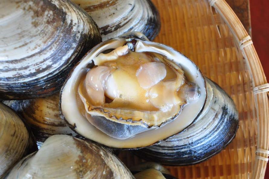
Hokugen shirasu (northernmost whitebait)
Gourmet
- 14
-
Natori City Hokugen Shirasu (Whitebait)
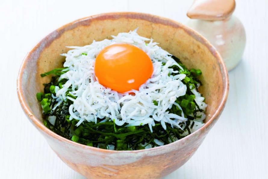
Kama-age (boiled) shirasu rice bowl
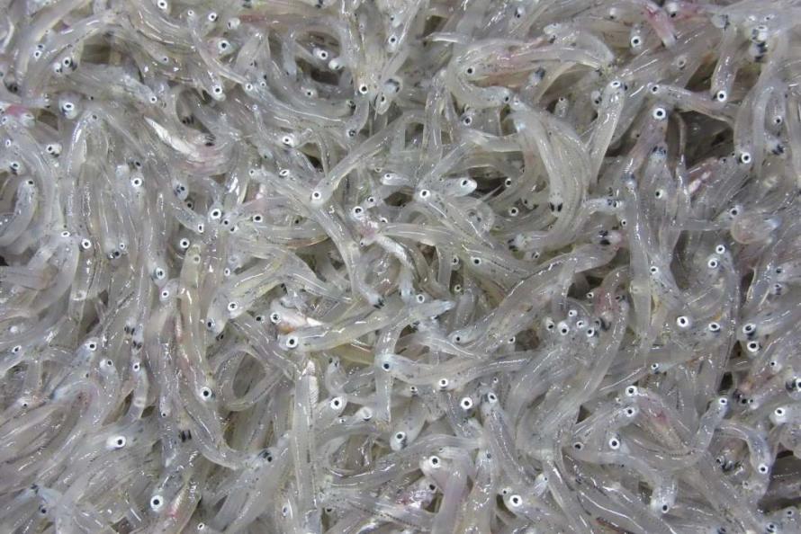
Shimmering fresh shirasu
In July 2017, full-scale shirasu or whitebait fishing resumed in four areas of Miyagi (Sendai City, Natori City, Watari Town and Yamamoto Town), including the Yuriage fishing port in Natori City, which is famously known as the northernmost point in Japan to catch shirasu. (“Hokugen” means “northernmost.”) The fishing season is from July to November. Fresh sashimi and rice bowl dishes made with shirasu can be enjoyed at local restaurants. In addition, boiled and simmered shirasu processed products are sold at local shops.
Contact: Natori City Tourism and Products Association
Phone: 022-382-6526
Website: https://www.kankou.natori.miyagi.jp/tokusan/7646
Natori City
Located at the entrance to southern Miyagi Prefecture, the city of Natori borders the southern part of Sendai City and stretches from the Pacific Ocean to the hills. The city is conveniently connected to Sendai Station via the Sendai Airport Access Line train, which takes only 15 minutes. Sendai Airport is only 5 minutes away. Because of this rail link convenience, Natori has become a Sendai commuter town, and new housing developments continue to be built, attracting more commercial facilities.
After the Great East Japan Earthquake, the entire coastal area from the Yuriage area to Sendai Airport were struck by the tsunami, resulting in 923 deaths and 38 people missing. A total of 2,801 houses were completely destroyed, and 1,129 were partially damaged*.
*Source: The Great East Japan Earthquake Record of Natori City, as of March 31, 2014 (Natori City)
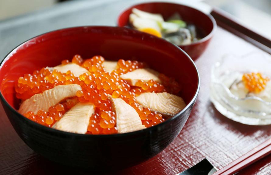
Harako Meshi
Gourmet
- 15
-
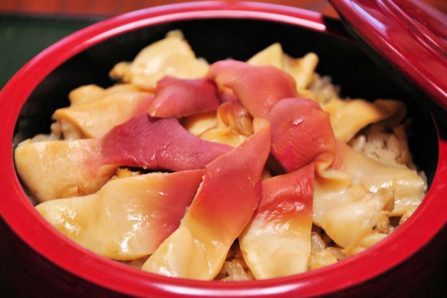
Watari Town/Yamamoto Town Harako Meshi and Hokki Meshi
Hokki Meshi
Surf clams (hokki-gai)
Harako Meshi
Harako meshi is a regional dish of Watari Town and Yamamoto Town, consisting of rice cooked in a broth of simmered autumn salmon, topped with salmon meat and roe (ikura). The dish is well-known for its delicious taste in Miyagi Prefecture. In its place of origin—the Arahama area of Watari Town—the dish is familiar, home-style cooking. Many restaurants in Watari Town and Yamamoto Town serve it from early September to early December, when it is in season.
Hokki Meshi
Hokki meshi is another local delicacy of Watari Town and Yamamoto Town. It features rice cooked in the broth of boiled surf clams (hokki-gai), topped with bright red clam meat. After the disaster, surf clam fishing had to be suspended due to debris on the seafloor, but with the introduction of new fishing equipment, fishing was resumed and now visitors can enjoy the dish at many restaurants in Watari Town and Yamamoto Town from mid-December to late March, which is the surf clam fishing season.
Watari Town
The town of Watari is located in the southern part of Miyagi Prefecture, bordered by the Abukuma River to the north, the Pacific Ocean to the east, and the Abukuma Highlands to the west. The town is blessed with a beautiful natural environment and enjoys mild winters and cool summers. The local economy is mainly based on agriculture, particularly rice cultivation, as well as greenhouse horticulture and fruit growing, which are all well-suited to the geographical conditions. Watari Town boasts the largest strawberry production in the Tohoku region, and the town also has thriving fisheries and manufacturing. Plus, Watari Town is known for its traditional local dish, harako meshi, which has a 400-year history.
The tsunami flooded around 35 square kilometers, approximately 48% of the town’s total area. There was a severe impact not only on fisheries but also on farmland and agricultural facilities, with rice cultivation forced to be suspended due to salt damage. About 93% of the strawberry farmers were also affected, devastating this fresh produce, as well.
Torinoumi Park in the Arahama area, which was hard hit by the tsunami, lost all of its facilities, including a track and athletic field and playground equipment. However, a reconstruction project was completed in August 2021 and the park was reopened as a 27-hectare comprehensive park featuring an artificial turf soccer field, baseball field, and multi-purpose open field area.
In addition, a new street-style skateboard park was built at the park, attracting people from both inside and outside of the town and creating a lively atmosphere.
Yamamoto Town
Yamamoto Town is located at the southeastern end of Miyagi Prefecture along the Pacific Ocean with the Abukuma Highlands to the west. The town has a mild climate and plenty of natural greenery and is blessed with abundance from the sea, mountains, and countryside. Yamamoto’s main industry is agriculture; the town is one of the largest producers of strawberries and apples in the prefecture. It is also known for Shine Muscat grapes and surf clams, seasonal specialties for visitors to enjoy.
The tsunami due to the Great East Japan Earthquake inundated 24 square kilometers, equivalent to 37.2% of the town’s total area. Debris covered the land from the coast to National Route 6; 77.8% of farmland was affected, and 90% of strawberry cultivation facilities were destroyed. Damage to lifelines and transportation facilities was also extensive. The railroad tracks south of Yamashita Station on the JR Joban Line were washed out, and major roads along the coast were destroyed or made impassable. The town’s only fishing port, Isohama Fishing Port, ceased to function due to the destruction of its access road and breakwater. In addition, food-related and metal-related factories were either completely or partially destroyed, causing devastating damage to the town’s industrial base.
Fully ripe strawberries
Gourmet
- 16
-
Watari Town/Yamamoto Town Strawberries

Vitamin-rich strawberries for dessert
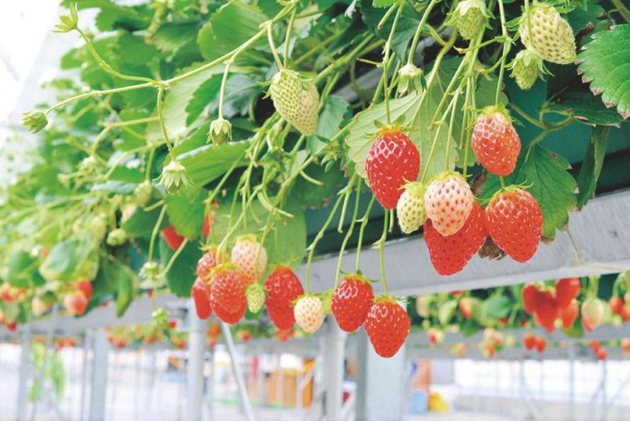
trawberry picking is also fun!
The towns of Watari and Yamamoto boast the highest strawberry production in the Tohoku region. In addition to Miyagi Prefecture’s original strawberry varieties such as Mou Ikko and Niko Niko Berry, other cultivars such as Tochi Otome and Beni Hoppe are also grown here. The strawberries grown in this region are highly valued throughout Japan for their good balance of sweetness and acidity thanks to a suitable climate and the meticulous care of the growers. In addition to being sold fresh, strawberries are used in a variety of processed products such as wine and jam.
Watari Town
The town of Watari is located in the southern part of Miyagi Prefecture, bordered by the Abukuma River to the north, the Pacific Ocean to the east, and the Abukuma Highlands to the west. The town is blessed with a beautiful natural environment and enjoys mild winters and cool summers. The local economy is mainly based on agriculture, particularly rice cultivation, as well as greenhouse horticulture and fruit growing, which are all well-suited to the geographical conditions. Watari Town boasts the largest strawberry production in the Tohoku region, and the town also has thriving fisheries and manufacturing. Plus, Watari Town is known for its traditional local dish, harako meshi, which has a 400-year history.
The tsunami flooded around 35 square kilometers, approximately 48% of the town’s total area. There was a severe impact not only on fisheries but also on farmland and agricultural facilities, with rice cultivation forced to be suspended due to salt damage. About 93% of the strawberry farmers were also affected, devastating this fresh produce, as well.
Torinoumi Park in the Arahama area, which was hard hit by the tsunami, lost all of its facilities, including a track and athletic field and playground equipment. However, a reconstruction project was completed in August 2021 and the park was reopened as a 27-hectare comprehensive park featuring an artificial turf soccer field, baseball field, and multi-purpose open field area.
In addition, a new street-style skateboard park was built at the park, attracting people from both inside and outside of the town and creating a lively atmosphere.
Yamamoto Town
Yamamoto Town is located at the southeastern end of Miyagi Prefecture along the Pacific Ocean with the Abukuma Highlands to the west. The town has a mild climate and plenty of natural greenery and is blessed with abundance from the sea, mountains, and countryside. Yamamoto’s main industry is agriculture; the town is one of the largest producers of strawberries and apples in the prefecture. It is also known for Shine Muscat grapes and surf clams, seasonal specialties for visitors to enjoy.
The tsunami due to the Great East Japan Earthquake inundated 24 square kilometers, equivalent to 37.2% of the town’s total area. Debris covered the land from the coast to National Route 6; 77.8% of farmland was affected, and 90% of strawberry cultivation facilities were destroyed. Damage to lifelines and transportation facilities was also extensive. The railroad tracks south of Yamashita Station on the JR Joban Line were washed out, and major roads along the coast were destroyed or made impassable. The town’s only fishing port, Isohama Fishing Port, ceased to function due to the destruction of its access road and breakwater. In addition, food-related and metal-related factories were either completely or partially destroyed, causing devastating damage to the town’s industrial base.